Valdurenque
| Valdurenque | ||
|---|---|---|

|
|
|
| region | Occitania | |
| Department | Camouflage | |
| Arrondissement | Castres | |
| Canton | Mazamet-1 | |
| Community association | Castres Mazamet | |
| Coordinates | 43 ° 34 ′ N , 2 ° 19 ′ E | |
| height | 191-329 m | |
| surface | 5.99 km 2 | |
| Residents | 835 (January 1, 2017) | |
| Population density | 139 inhabitants / km 2 | |
| Post Code | 81090 | |
| INSEE code | 81307 | |
| Website | http://valdurenque.com/ | |
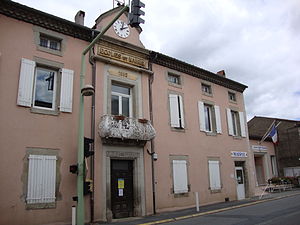
 Town Hall (Mairie) and School of Valdurenque |
||
Valdurenque ( Occitan : Val Durenca ) is a French commune with 835 inhabitants (as of January 1, 2017) in the Tarn department in the Occitanie region . The municipality belongs to the arrondissement of Castres and the canton of Mazamet-1 (until 2015: canton of Labruguière ).
geography
Valdurenque is about five kilometers southeast of the city center of Castres . The municipality is crossed by the Durenque River. Valdurenque is surrounded by the neighboring communities of Castres in the north and north-west, Noailhac in the east, Payrin-Augmontel in the east and south-east, Caucalières in the south and Lagarrigue in the west.
Population development
| year | 1962 | 1968 | 1975 | 1982 | 1990 | 1999 | 2008 | 2013 |
| Residents | 371 | 421 | 494 | 640 | 628 | 700 | 765 | 814 |
| Source: Cassini and INSEE | ||||||||
Attractions
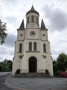
- Saint-Louis church
- Gaïx Castle, ruin
Web links
Commons : Valdurenque - collection of images, videos and audio files

