
Brassac (Tarn)
|
Brassac Braçac |
||
|---|---|---|

|
|
|
| region | Occitania | |
| Department | Camouflage | |
| Arrondissement | Castres | |
| Canton | Les Hautes Terres d'Oc | |
| Community association | Sidobre Vals et Plateaux | |
| Coordinates | 43 ° 38 ′ N , 2 ° 30 ′ E | |
| height | 463-828 m | |
| surface | 23.87 km 2 | |
| Residents | 1,290 (January 1, 2017) | |
| Population density | 54 inhabitants / km 2 | |
| Post Code | 81260 | |
| INSEE code | 81037 | |
| Website | http://www.brassac.fr/ | |
 Town hall (Mairie) of Brassac |
||

Brassac ( Occitan : Braçac ) is a southern French municipality with 1,290 inhabitants (as of January 1, 2017) in the Tarn department in the Occitania region . Brassac belongs to the Arrondissement of Castres and the canton of Les Hautes Terres d'Oc (until 2015: canton of Brassac ). The inhabitants are called Brassagais .
location
Brassac is located on the Agout River and in the Haut-Languedoc Regional Nature Park , about 20 east-northeast from Castres . Brassac is surrounded by the neighboring communities of Fontrieu with Castelnau-de-Brassac in the north and east, Anglès in the southeast, Lasfaillades in the south and Le Bez in the west.
Brassac is a stage on the Via Tolosana , one of the four historical " Routes of the St. James pilgrims in France ". The former route nationale 622 (today's D622) runs through the municipality .
Population development
| year | 1962 | 1968 | 1975 | 1982 | 1990 | 1999 | 2006 | 2013 |
| Residents | 1,578 | 1.611 | 1,629 | 1,671 | 1,539 | 1,427 | 1,438 | 1,331 |
| Source: Cassini and INSEE | ||||||||
Attractions
- Saint-Georges church
- Castles (one of them is the town hall)
- Bridge over the agout from the 12th century
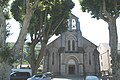
Saint-Georges church

medieval bridge over the agout


Personalities
- André Claveau (1915-2003), chansonnier