Barre (Tarn)
| Barre | ||
|---|---|---|
|
|
||
| region | Occitania | |
| Department | Camouflage | |
| Arrondissement | Castres | |
| Canton | Les Hautes Terres d'Oc | |
| Community association | Monts de Lacaune and Montagne du Haut Languedoc | |
| Coordinates | 43 ° 45 ′ N , 2 ° 50 ′ E | |
| height | 857-1,065 m | |
| surface | 15.07 km 2 | |
| Residents | 207 (January 1, 2017) | |
| Population density | 14 inhabitants / km 2 | |
| Post Code | 81320 | |
| INSEE code | 81023 | |
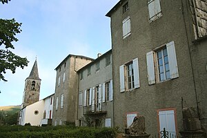
 Barre (hamlet of Gos) - Église Saint-Joseph and Château de Gos |
||
Barre is a southern French municipality with 207 inhabitants (as of January 1, 2017 ) consisting of several hamlets ( hameaux ) in the wider area of Albi in the Tarn department in the Occitania region .
location
Barre is located in the southwestern foothills of the Massif Central at the foot of the mountains Mont Barre (1062 m) and Mont Gos (1065 m) in the cultural landscape of the Albigeois approx. 79 km (driving distance) southeast of Albi in the Regional Nature Park Haut-Languedoc at an altitude of approx. 925 m above sea level d. M. The climate is temperate; Rain falls all year round.
Population development
| year | 1800 | 1851 | 1901 | 1954 | 1999 | 2014 |
| Residents | 1092 | 1453 | 646 | 373 | 215 | 204 |
The continuous decline in the number of inhabitants since the middle of the 19th century is mainly due to the mechanization of agriculture and the associated loss of jobs.
economy
The residents of the village traditionally lived as self-sufficient farmers from agriculture, which also included cattle breeding (sheep, goats).
history
The Château de Muratel belonging to the municipality of Barre is mentioned as early as the 12th century; Most of it was demolished during the French Revolution . During this time and in the 19th century, Barre was repeatedly merged with some neighboring villages (e.g. Cabannes ) and separated again until the current municipality was finally created. In addition to the main town of Barre , the hamlet of Gos should be mentioned.
Attractions
- Some of the houses in the community are still built from quarry stones , but most of them are plastered.
- In the hamlet of Gos there is a stone-sighted, partially vaulted bakery from the 17th or 18th century, in whose anteroom some tools and objects of rural life are shown.
- In the Cantoul area there is a Neolithic menhir with incisions (dagger or sword), which is called a statue menhir . Another stone ( La Roche de Combeynart ) was only identified as a statue menhir in 1987. A copy of the stone called Plo de la Matte can be found in the adjacent areas of the Aveyron department .

