Villemagne-l'Argentière
| Villemagne-l'Argentière | ||
|---|---|---|

|
|
|
| region | Occitania | |
| Department | Herault | |
| Arrondissement | Beziers | |
| Canton | Clermont-l'Hérault | |
| Community association | Grand Orb | |
| Coordinates | 43 ° 37 ' N , 3 ° 7' E | |
| height | 187-481 m | |
| surface | 8.06 km 2 | |
| Residents | 433 (January 1, 2017) | |
| Population density | 54 inhabitants / km 2 | |
| Post Code | 34600 | |
| INSEE code | 34335 | |
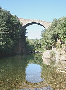
 Village view |
||
Villemagne-l'Argentière is a southern French municipality with 433 inhabitants (as of January 1, 2017) in the Hérault department in the Occitanie region . It is located at the foot of the Cevennes in the valley of the Mare river . The municipality is part of the Haut-Languedoc Regional Nature Park .
Demographics
| year | 1962 | 1968 | 1975 | 1982 | 1990 | 1999 | 2008 | 2017 |
|---|---|---|---|---|---|---|---|---|
| Residents | 308 | 320 | 291 | 317 | 365 | 429 | 425 | 433 |
Web links
Commons : Villemagne-l'Argentière - Album with pictures, videos and audio files

