
Nizas (Herault)
|
Nizas Nisàs |
||
|---|---|---|
.svg)
|
|
|
| region | Occitania | |
| Department | Herault | |
| Arrondissement | Beziers | |
| Canton | Mèze | |
| Community association | Hérault Méditerranée | |
| Coordinates | 43 ° 31 ' N , 3 ° 24' E | |
| height | 19-131 m | |
| surface | 8.53 km 2 | |
| Residents | 670 (January 1, 2017) | |
| Population density | 79 inhabitants / km 2 | |
| Post Code | 34320 | |
| INSEE code | 34184 | |

Nizas ( Occitan : Nisàs ) is a place and a municipality in the south of France with 670 inhabitants (as of January 1, 2017) in the Hérault department in the Occitania region . The municipality belongs to the arrondissement of Béziers and the canton of Mèze (until 2015: canton of Montagnac ). The inhabitants are called Nizaçois .
location
Nizas is located about 24 kilometers northeast of Béziers and about 39 kilometers west-southwest of Montpellier am Hérault . Nizas is surrounded by the neighboring communities of Fontès in the north and northwest, Adissan in the north, Paulhan in the northeast, Cazouls-d'Hérault in the east and southeast, Lézignan-la-Cèbe in the south and southeast, Pézenas in the south and Caux in the west.
The A75 autoroute runs through the east of the municipality . In the south is the Pézenas-Nizas airfield . The place belongs to the Clairette du Languedoc wine region .
Population development
| year | 1962 | 1968 | 1975 | 1982 | 1990 | 1999 | 2006 | 2017 |
| Residents | 506 | 504 | 391 | 398 | 459 | 525 | 542 | 670 |
| Sources: Cassini and INSEE | ||||||||
Attractions
- Notre-Dame church
- tower
- Carrion-Nizas Castle
- Griffin Square ( Place du Griffe )
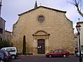
Notre-Dame church

Carrion-Nizas Castle

