Basville
| Basville | ||
|---|---|---|
|
|
||
| region | Nouvelle-Aquitaine | |
| Department | Creuse | |
| Arrondissement | Aubusson | |
| Canton | Canton of Auzances | |
| Community association | Chénérailles, Auzances / Bellegarde and Haut Pays Marchois | |
| Coordinates | 45 ° 52 ' N , 2 ° 24' E | |
| height | 675-826 m | |
| surface | 22.57 km 2 | |
| Residents | 159 (January 1, 2017) | |
| Population density | 7 inhabitants / km 2 | |
| Post Code | 23260 | |
| INSEE code | 23017 | |
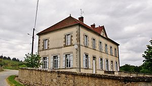
 Mairie Basville |
||
Basville is a municipality in the Massif Central in France . It belongs to the Nouvelle-Aquitaine region , the Creuse department , the Aubusson arrondissement and the Auzances canton .
geography
Basville is located in the Millevaches en Limousin Regional Nature Park and borders in the north-west on Saint-Oradoux-près-Crocq , in the north on La Villeneuve , in the north-east on La Mazière-aux-Bons-Hommes , in the east on La Celle , in the south-east on Giat , in the south on Fernoël and in the south-west on Flayat and Crocq . The rivers Tardes and Tyx have their source in the municipality .
history
Earlier known place names were Basvila (1373) and Bassavilla (1392).
The previously independent municipality of Saint-Alvard was incorporated into Basville on December 14, 1836.
Population development
| year | 1962 | 1968 | 1975 | 1982 | 1990 | 1999 | 2008 | 2012 |
|---|---|---|---|---|---|---|---|---|
| Residents | 323 | 306 | 300 | 274 | 224 | 195 | 178 | 175 |
Attractions
- Church of Sainte-Anne

