
Puy-Malsignat
| Puy-Malsignat | ||
|---|---|---|
|
||
| region | Nouvelle-Aquitaine | |
| Department | Creuse | |
| Arrondissement | Aubusson | |
| Canton | Gouzon | |
| Community association | Chénérailles, Auzances / Bellegarde and Haut Pays Marchois | |
| Coordinates | 46 ° 2 ' N , 2 ° 13' E | |
| height | 496-616 m | |
| surface | 12.61 km 2 | |
| Residents | 159 (January 1, 2017) | |
| Population density | 13 inhabitants / km 2 | |
| Post Code | 23130 | |
| INSEE code | 23159 | |

Puy-Malsignat is a commune in France . It belongs to the Nouvelle-Aquitaine region , the Creuse department , the Aubusson arrondissement and the Gouzon canton . It is bordered by Issoudun-Létrieix in the northwest , Peyrat-la-Nonière in the northeast, Champagnat in the east, Saint-Maixant in the south and Saint-Médard-la-Rochette in the west .
Population development
| year | 1962 | 1968 | 1975 | 1982 | 1990 | 1999 | 2008 | 2013 |
|---|---|---|---|---|---|---|---|---|
| Residents | 356 | 244 | 215 | 213 | 194 | 194 | 165 | 174 |
Attractions
- Margeleix Castle, Monument historique
- Saint-Thomas Church, Monument historique
- Tower of Puy-Malsignat, Monument historique

Mageleix Castle

Saint Thomas Church
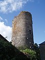
Tower of Malsignat


Web links
Commons : Puy-Malsignat - collection of images, videos and audio files