
Clugnat
| Clugnat | ||
|---|---|---|

|
|
|
| region | Nouvelle-Aquitaine | |
| Department | Creuse | |
| Arrondissement | Aubusson | |
| Canton | Boussac | |
| Community association | Creuse Confluence | |
| Coordinates | 46 ° 19 ′ N , 2 ° 7 ′ E | |
| height | 287-537 m | |
| surface | 42.42 km 2 | |
| Residents | 645 (January 1, 2017) | |
| Population density | 15 inhabitants / km 2 | |
| Post Code | 23270 | |
| INSEE code | 23064 | |
 Mairie Clugnat |
||

Clugnat is a commune in the Massif Central in France . It belongs to the Nouvelle-Aquitaine region , the Creuse department , the Aubusson arrondissement and the Boussac canton .
geography
In Clugnat the Verraux comes from the south and flows into the Petite Creuse . The municipality borders Bétête and Malleret-Boussac to the north, Toulx-Sainte-Croix and Saint-Silvain-sous-Toulx to the east, Domeyrot , Parsac-Rimondeix (point of contact), Blaudeix and Ladapeyre to the west and Jalesches and to the west Saint-Dizier-les-Domaines .
Population development
| year | 1962 | 1968 | 1975 | 1982 | 1990 | 1999 | 2008 | 2013 |
|---|---|---|---|---|---|---|---|---|
| Residents | 1004 | 916 | 836 | 809 | 752 | 687 | 686 | 687 |
Attractions
- Saint-Martial Church, Monument historique
- Saint-Jean chapel
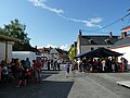
Village festival
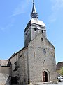
Saint-Martial church

Saint-Jean chapel
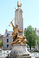
War memorial


Web links
Commons : Clugnat - collection of images, videos and audio files