
Saint-Georges-Nigremont
| Saint-Georges-Nigremont | ||
|---|---|---|
.svg)
|
|
|
| region | Nouvelle-Aquitaine | |
| Department | Creuse | |
| Arrondissement | Aubusson | |
| Canton | Auzances | |
| Community association | Chénérailles, Auzances / Bellegarde and Haut Pays Marchois | |
| Coordinates | 45 ° 50 ′ N , 2 ° 16 ′ E | |
| height | 589-801 m | |
| surface | 18.59 km 2 | |
| Residents | 129 (January 1, 2017) | |
| Population density | 7 inhabitants / km 2 | |
| Post Code | 23500 | |
| INSEE code | 23198 | |

Saint-Georges-Nigremont is a commune in the Massif Central in France . It belongs to the Nouvelle-Aquitaine region , the Creuse department , the Aubusson arrondissement and the Auzances canton . It is bordered by Pontcharraud to the north, Saint-Maurice-près-Crocq to the northeast, Saint-Agnant-près-Crocq to the southeast, Magnat-l'Étrange to the south, Poussanges to the west and Saint-Frion to the northwest .
Population development
| year | 1962 | 1968 | 1975 | 1982 | 1990 | 1999 | 2008 | 2012 |
|---|---|---|---|---|---|---|---|---|
| Residents | 290 | 246 | 200 | 183 | 156 | 168 | 164 | 156 |
Attractions
- Notre Dame de l'Emigration
- Saint-Georges church
- 15th century castle in the Les Écurettes district
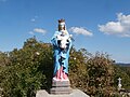
Notre Dame de l'Emigration

Saint-Georges church


Web links
Commons : Saint-Georges-Nigremont - Collection of images, videos and audio files