Blessac
| Blessac | ||
|---|---|---|

|
|
|
| region | Nouvelle-Aquitaine | |
| Department | Creuse | |
| Arrondissement | Aubusson | |
| Canton | Aubusson | |
| Community association | Creuse Grand Sud | |
| Coordinates | 45 ° 58 ' N , 2 ° 8' E | |
| height | 406-665 m | |
| surface | 17.75 km 2 | |
| Residents | 533 (January 1, 2017) | |
| Population density | 30 inhabitants / km 2 | |
| Post Code | 23200 | |
| INSEE code | 23024 | |
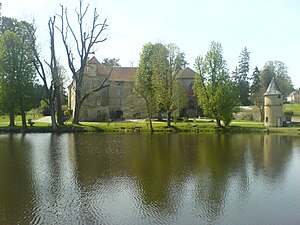
 The castle of Blessac |
||
Blessac is a municipality with 533 inhabitants (as of January 1, 2017) in the Massif Central in France . It belongs to the Nouvelle-Aquitaine region , the Creuse department , the Aubusson arrondissement and the Aubusson canton . It borders in the north-west on Saint-Sulpice-les-Champs , in the north on Ars and Saint-Médard-la-Rochette , in the north-east on Alleyrat , in the east on Aubusson , in the south on Saint-Marc-à-Frongier and in the west Saint-Michel-de-Veisse .
Blessac is affected by the Creuse in the east . There it takes up the brook called Ruisseau de Grouille, which rises in the municipality marker.
Attractions
- Saint-Martial church
- Saint-Thomas-de-Cantorbéry church in the La Borne district
- Dolmen Pierre de la Fade in a wooded area northwest of Blessac, created in 1889, now a monument historique
- Blessac Castle
Population development
| year | 1962 | 1968 | 1975 | 1982 | 1990 | 1999 | 2004 | 2006 | 2009 | 2012 |
|---|---|---|---|---|---|---|---|---|---|---|
| Residents | 340 | 316 | 342 | 411 | 495 | 488 | 510 | 514 | 524 | 526 |
Web links
Commons : Blessac - collection of images, videos and audio files

