
Budelière
| Budelière | ||
|---|---|---|
|
||
| region | Nouvelle-Aquitaine | |
| Department | Creuse | |
| Arrondissement | Aubusson | |
| Canton | Evaux-les-Bains | |
| Community association | Creuse Confluence | |
| Coordinates | 46 ° 13 ' N , 2 ° 28' E | |
| height | 293-449 m | |
| surface | 25.07 km 2 | |
| Residents | 717 (January 1, 2017) | |
| Population density | 29 inhabitants / km 2 | |
| Post Code | 23170 | |
| INSEE code | 23035 | |
 Place view |
||

Budelière is a commune in France . It belongs to the Nouvelle-Aquitaine region , the Creuse department , the Aubusson arrondissement and the Évaux-les-Bains canton . The residents call themselves Budeliérois .
geography
The Tardes flows in Budelière as a left tributary into the Cher . They flow through a reservoir , which also forms the municipal boundary. The settlement area consists of the villages of Les Bruyères, Chassagne, Chassat, La Chatelane, Le Châtelet, Chaumonteil, Chévechère, Le Clos, Les Coutures, La Denèche, La Gare, Grand Cros, Lonlevade, Madelaine, Maschaumeix, Montbardoux, La Montenelle, Moulin Chaponnet, Petit Cros, Pont et Poirier, Richeboeuf, Rochette, Le Rouchaud, Sac, Saget, Sauzet, Thermont, La Trimouille, Les Trimouilles, Vernon, Vernude and La Villederie. The municipality borders Viersat to the northwest , Teillet-Argenty to the northeast, Mazirat (point of contact) to the east, Évaux-les-Bains to the southeast and Chambon-sur-Voueize to the southwest .
The nearest train station is in Évaux-les-Bains . The Bourges - Miécaze railway line passes the La Gare district.
Attractions
- Viaduct over the Tardes, Monument historique
- Saint-Gaudens church
- Saint-Martial church in the Le Châtelet district
- Saint-Marien chapel
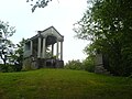
- Chapel of Sainte-Radégonde
- Suspension bridge over the Tardes

Viaduct over the Tardes
Saint-Marien chapel

Chapel of Sainte-Radégonde
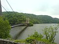
Suspension bridge over the Tardes between Budelière and Évaux-les-Bains


Population development
| year | 1962 | 1968 | 1975 | 1982 | 1990 | 1999 | 2008 | 2013 |
|---|---|---|---|---|---|---|---|---|
| Residents | 742 | 689 | 623 | 715 | 756 | 755 | 793 | 755 |