
Sermur
| Sermur | ||
|---|---|---|
|
||
| region | Nouvelle-Aquitaine | |
| Department | Creuse | |
| Arrondissement | Aubusson | |
| Canton | Auzances | |
| Community association | Chénérailles, Auzances / Bellegarde and Haut Pays Marchois | |
| Coordinates | 45 ° 59 ′ N , 2 ° 26 ′ E | |
| height | 607-725 m | |
| surface | 19.50 km 2 | |
| Residents | 133 (January 1, 2017) | |
| Population density | 7 inhabitants / km 2 | |
| Post Code | 23700 | |
| INSEE code | 23171 | |
_(flickruser1banaan).jpg) Saint-Hilaire church |
||

Sermur is a municipality in the Massif Central in France . It belongs to the Nouvelle-Aquitaine region , the Creuse department , the Aubusson arrondissement and the Auzances canton . It borders on Bussière-Nouvelle and Le Compas to the north, Brousse to the east, Lioux-les-Monges to the southeast, Mautes to the south and Lupersat to the west .
Population development
| year | 1962 | 1968 | 1975 | 1982 | 1990 | 1999 | 2008 | 2012 |
|---|---|---|---|---|---|---|---|---|
| Residents | 276 | 238 | 209 | 155 | 139 | 128 | 100 | 120 |
Attractions
- Saint-Hilaire church
- Tower of Sermur, created in the 11th century to 712 meters above sea level and during the Hundred Years War destroyed so that a ruin was left since 1975, a historique monument is
- Château de La Combe , Monument historique since 2011
- Pigeonnier-Chapelle de La Chaze , Monument historique since 2010
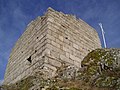
The ruined tower of Sermur

The hall cross at the tower ruins

View from the ruined tower to the Monts d'Auvergne


Web links
Commons : Sermur - collection of images, videos and audio files