
Mérinchal
| Mérinchal | ||
|---|---|---|
.svg)
|
|
|
| region | Nouvelle-Aquitaine | |
| Department | Creuse | |
| Arrondissement | Aubusson | |
| Canton | Auzances | |
| Community association | Chénérailles, Auzances / Bellegarde and Haut Pays Marchois | |
| Coordinates | 45 ° 55 ' N , 2 ° 29' E | |
| height | 656-784 m | |
| surface | 45.45 km 2 | |
| Residents | 720 (January 1, 2017) | |
| Population density | 16 inhabitants / km 2 | |
| Post Code | 23420 | |
| INSEE code | 23131 | |
.JPG) Château de la Motte with the Mairie |
||

Mérinchal is a municipality in the Massif Central in France . It belongs to the Nouvelle-Aquitaine region , the Creuse department , the Aubusson arrondissement and the Auzances canton . The residents call themselves Mérinchalois or Mérinchaux .
geography
The municipality in the Millevaches en Limousin Regional Nature Park borders on Chard to the north, Dontreix to the northeast, Montel-de-Gelat and Condat-en-Combraille to the east, Saint-Avit to the southeast, La Celle to the south and La Celle to the west La Mazière-aux-Bons-Hommes and in the northwest at Lioux-les-Monges . In Mérinchal, at about 715 m. ü. M. rises from the Cher and then flows north.
history
Earlier place names were "Mairenchalm" (1150) and "Mayrenchalm" (1231).
Population development
| year | 1962 | 1968 | 1975 | 1982 | 1990 | 1999 | 2008 | 2012 |
|---|---|---|---|---|---|---|---|---|
| Residents | 1199 | 1187 | 1159 | 1032 | 907 | 821 | 745 | 737 |
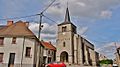
Attractions
- Floor cross from 1865
- Saint-Pierre church
- Château de la Motte
Saint-Pierre church

memorial

Château de la Motte

One of the small lakes in Mérinchal
.JPG)
.JPG)
.JPG)
.JPG)