
Pioneer
| Pioneer | ||
|---|---|---|
|
||
| region | Nouvelle-Aquitaine | |
| Department | Creuse | |
| Arrondissement | Aubusson | |
| Canton | Gouzon | |
| Community association | Creuse Confluence | |
| Coordinates | 46 ° 10 ′ N , 2 ° 2 ′ E | |
| height | 320-573 m | |
| surface | 41.77 km 2 | |
| Residents | 758 (January 1, 2017) | |
| Population density | 18 inhabitants / km 2 | |
| Post Code | 23140 | |
| INSEE code | 23154 | |

Pionnat is a French commune in the Creuse in the region Nouvelle-Aquitaine . It belongs to the arrondissement of Aubusson and the canton of Gouzon . The residents call themselves Pionnatois or Pionnatoises .
Geography and infrastructure
The municipality is bordered to the northwest and north by Ajain , to the northeast by Ladapeyre , to the east by Jarnages and Vigeville , to the southeast by Cressat , to the south by Ahun , to the southwest by Mazeirat and to the west by Saint-Laurent .
The Creuse touches Pionnat in the south. A railway line crosses the river on a viaduct. The nearest train station is not far from the municipality in Ahun. The route national 145 , combined with the European route 62 , crosses Pionnat in the north. The closest connections to this expressway are in Jarnages and Ajain .
Population development
| year | 1962 | 1968 | 1975 | 1982 | 1990 | 1999 | 2004 | 2006 | 2009 | 2012 |
|---|---|---|---|---|---|---|---|---|---|---|
| Residents | 961 | 847 | 741 | 726 | 682 | 744 | 764 | 756 | 762 | 754 |
Attractions
- Dolmen Pierre Fade by Ménardeix
- Railway viaduct over the Creuse in the south of the municipality, recognized as a monument historique since 1975
- Oppidum de Châteauvieux, a monument historique since 1984
- Abbaye des Ternes, a monument historique since 1981

Railway viaduct over the Creuse
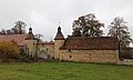
Abbaye des Ternes, former Cölestiner monastery (1338–1779)


