
Le Compas
| Le Compas | ||
|---|---|---|
|
||
| region | Nouvelle-Aquitaine | |
| Department | Creuse | |
| Arrondissement | Aubusson | |
| Canton | Auzances | |
| Community association | Chénérailles, Auzances / Bellegarde and Haut Pays Marchois | |
| Coordinates | 45 ° 59 ′ N , 2 ° 28 ′ E | |
| height | 546-688 m | |
| surface | 16.54 km 2 | |
| Residents | 212 (January 1, 2017) | |
| Population density | 13 inhabitants / km 2 | |
| Post Code | 23700 | |
| INSEE code | 23066 | |
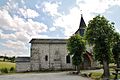
.JPG) Mairie Le Compas |
||

Le Compas is a commune in the Massif Central in France . It belongs to the Nouvelle-Aquitaine region , the Creuse department , the Aubusson arrondissement and the Auzances canton . The former Route nationale 696 leads via Le Compas. The neighboring municipalities are Rougnat in the north, Auzances in the northeast, Les Mars in the east, Brousse and Sermur in the south and Bussière-Nouvelle in the west.
Attractions
- Saint-Martial church, built in the 17th and 18th centuries
- Chapelle du Theil
- Château de Vauchaussade

War memorial
Saint-Martial church
.JPG)
.JPG)
Population development
| year | 1962 | 1968 | 1975 | 1982 | 1990 | 1999 | 2008 | 2012 |
|---|---|---|---|---|---|---|---|---|
| Residents | 352 | 332 | 270 | 235 | 216 | 197 | 218 | 209 |
Web links
Commons : Le Compas - collection of images, videos and audio files