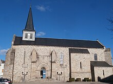
Vallière (Creuse)
| Vallière | ||
|---|---|---|
|
|
||
| region | Nouvelle-Aquitaine | |
| Department | Creuse | |
| Arrondissement | Aubusson | |
| Canton | Felletin | |
| Community association | Creuse Grand Sud | |
| Coordinates | 45 ° 54 ' N , 2 ° 2' E | |
| height | 494-708 m | |
| surface | 48.42 km 2 | |
| Residents | 723 (January 1, 2017) | |
| Population density | 15 inhabitants / km 2 | |
| Post Code | 23120 | |
| INSEE code | 23257 | |
Vallière is a commune in the Massif Central in France . It belongs to the Nouvelle-Aquitaine region , the Creuse department , the Aubusson arrondissement and the Felletin . It is bordered by Banize to the north-west, Saint-Michel-de-Veisse to the north, Saint-Marc-à-Frongier to the east, Saint-Quentin-la-Chabanne and La Nouaille to the south, and Saint-Yrieix to the south . la-Montagne and to the west at Le Monteil-au-Vicomte .
Population development
| year | 1962 | 1968 | 1975 | 1982 | 1990 | 1999 | 2008 | 2013 |
|---|---|---|---|---|---|---|---|---|
| Residents | 1126 | 994 | 940 | 885 | 814 | 774 | 755 | 770 |
Attractions
- Saint-Martin de Tours church
Web links
Commons : Vallière - collection of images, videos and audio files

