
Saint-Martin-du-Mont (Ain)
| Saint-Martin-du-Mont | ||
|---|---|---|
|
||
| region | Auvergne-Rhône-Alpes | |
| Department | Ain | |
| Arrondissement | Bourg-en-Bresse | |
| Canton | Ceyzériat | |
| Community association | Bassin de Bourg-en-Bresse | |
| Coordinates | 46 ° 6 ′ N , 5 ° 20 ′ E | |
| height | 246-556 m | |
| surface | 28.09 km 2 | |
| Residents | 1,826 (January 1, 2017) | |
| Population density | 65 inhabitants / km 2 | |
| Post Code | 01160 | |
| INSEE code | 01374 | |
| Website | saintmartindumont.fr | |
 The municipal administration ( mairie ) of Saint-Martin-du-Mont |
||

Saint-Martin-du-Mont is a French commune with 1,826 inhabitants (at January 1, 2017) in the department of Ain in the region Auvergne Rhône-Alpes . It belongs to the canton of Ceyzériat in the arrondissement of Bourg-en-Bresse .
geography
location
Saint-Martin-du-Mont is located at 365 m , about 14 kilometers southeast of the prefecture of Bourg-en-Bresse , 54 km northeast of the city of Lyon and 44 km east-southeast of the city of Mâcon (as the crow flies). The village is located at the southern foot of the Revermont and borders the historic province of Bresse to the west . Neighboring municipalities of Saint-Martin-du-Mont are Tossiat , Journans (point of contact) and Bohas-Meyriat-Rignat in the north, Neuville-sur-Ain in the east, Druillat in the south and La Tranclière and Certines in the west.
topography
The area of the 28.09 km 2 municipal area includes a section of the southern Revermont, the foothills of the French Jura . In the area of the municipality, the ridge of the Revermont rises abruptly and steeply from the evenly flat, 265 m plain of the Bresse, here its foot line runs straight in north-south direction. A strip of the fertile Bresse plain several kilometers wide still belongs to the municipality, it is mainly used for agriculture and is drained from several sewer systems . From the Revermont emerges the Suran river , which flows in small river loops parallel to the Ain in a south-westerly direction and near which the eastern municipal boundary of Saint-Martin runs. It is surrounded by a one kilometer wide valley floor into which the actual river bed has sunk by around 50 m. The area between the Suran valley and the western edge of the Revermont is mountainous with the Croix de la Dent ( 555 m ) as the highest point in the municipality. The agricultural use of the communal land in the Bresse plain and in the Suran valley makes up the majority with 38% arable land, 19% meadows and 5% others. About 32% of the area is forested.
Community structure
The municipality of Saint-Martin-du-Mont is spread over a number of smaller towns with historic housing stock as well as hamlets and farms. The different locations are:
- Salles ( 269 m ) in the north at the foot of the Revermont,
- Le Pied de la Côte and Le Farget ( 273 m ) at the foot of the Revermont directly below the main town,
- Le Molard ( 262 m ) in the west in the Bresse plain,
- La Chapelle ( 276 m ) in the south in the Bresse plain,
- the actual town center ( 265 m ) with the village church and municipal administration on the western flank of the Revermont,
- Gravelles ( 390 m ) in the north in a basin in the Revermont, it was a separate municipality until the French Revolution ,
- Confranchette in Revermont above the town center, divided into Confranchette-d'en-Haut ( 355 m ) and Confranchette-d'en-Bas ( 307 m ),
- Soblay ( 307 m ) in the Suran Valley.
history
In the Middle Ages there was a parish in Saint-Martin-du-Mont, which was first mentioned in 1267 as Parrochia Sancti Martini de Monte and belonged to the Archdiocese of Lyon . The Château de Pommier, located 200 m to the north, was the seat of a small lordship that included the lands of Saint-Martin. The places around Saint-Martin Chiloup, Confranchette, Gravelles, Molard and Soblay also date back to the Middle Ages and were first mentioned in 1341 or 1350. They had partially different owners and liege lords, including the Varambon lordship , the lords of Coligny followed by Thoire-Villars or the Counts of Savoy . In Chiloup there was a permanent house that belonged to a family of the same name. With the Treaty of Lyon in 1601, the entire Bresse finally came to France.

In June 1944, the German occupiers carried out shootings in Le Molard and burned a homestead and other houses. At the same time, the railway line was the target of sabotage by the Maquisards .
In the administrative structure after the French Revolution , Saint-Martin-du-Mont belonged to the canton of Pont-d'Ain until 2015 , after which it moved to the canton of Ceyzériat as part of the nationwide reorganization of the cantons .
Attractions
- The village church of Saint-Laurent in the center of Saint-Martin-du-Mont is a neo-Gothic building from the period from 1845 to 1857, which completely replaced the previous building, which was oriented across the current floor plan. The nave is divided into eight bays and spanned with ribbed vaults, while the side aisles have a simple groined vault . The apse is angular with five large stained glass windows . The bell tower stands over the porch.
- The Notre-Dame-de-l'Orme chapel overbuilds the remains of an elm (French: Orme ) that grew in this place from 1350 to 1653 and into which a Pietà is carved. From the originally larger church building from the period 1653–1670, the side of the choir, to which a small porch was added, still stands today. She has stained glass in two of her windows. The building was repaired and renovated around 1840 and 2000.

Notre-Dame-de-l'Orme chapel

Pietà of the chapel

Stained glass window with Louis the Saint

Stained glass with Teresa of Ávila


- The Château de La Roche.
- The Château de Pommier on a hill north of the town center. Its oldest parts date from the 13th century.
- The Château de Chiloup is a building from 1830 that was built on the site of the medieval fortress house.
- Numerous wash houses, ovens and wayside crosses can be found in various places in the municipality.

Historical view of the Château de la Roche
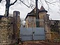
Entrance gate of the Château de la Roche
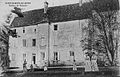
Historical view of the Château de Pommier
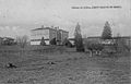
Historical view of the Château de Chiloup
.jpg)

.jpg)
.jpg)
population
| Population development | |
|---|---|
| year | Residents |
| 1962 | 1,019 |
| 1968 | 1.007 |
| 1975 | 909 |
| 1982 | 1,078 |
| 1990 | 1,179 |
| 1999 | 1,302 |
| 2006 | 1,505 |
| 2011 | 1,681 |
With 1,826 inhabitants (as of January 1, 2017), Saint-Martin-du-Mont is one of the smaller communities in the Ain department. After the population had fluctuated only slightly around 1700 in the 19th century, it fell in the 20th century to a low of 909 inhabitants in 1975. Since the 1980s, the population has increased again. The local residents of Saint-Martin-du-Mont are called Saint-Martinois (es) in French .
Economy and Infrastructure
Saint-Martin-du-Mont is still a predominantly agricultural village today . There are many companies active in the areas of field and livestock . On the southern slopes in Revermont, especially near Gravelles and Soblay, viticulture is also practiced. The community belongs to the protected designation of origin Bugey , it mainly produces sparkling wines from the varieties Poulsard and Gamay . In addition, there are now various local small businesses. In the meantime the village has also developed into a residential community. Many workers are commuters who work in the larger towns in the area, especially in the Bourg-en-Bresse area.

The department road D1075 and the former national road N75 , which connected Bourg-en-Bresse with Grenoble, run through the commune . From it side roads branch off to the different villages of Saint-Martin-du-Mont. Narrow streets in the Revermont connect Gravelles with the neighboring village of Rignat and Soblay with Neuville-sur-Ain. A few kilometers north of the municipality is the next motorway junction to the A40 in Tossiat , which bypasses the municipality on its western border. This is also where the Mâcon – Ambérieu-en-Bugey railway runs , with the Saint-Martin-du-Mont stop in Le Molard for TER Rhône-Alpes trains . The airport in the region is Lyon-St-Exupéry (62 km).
education
In Saint-Martin-du-Mont there is a state école primaire (elementary school with an integrated preschool ).
Parish partnership
Together with four other municipalities in Revermont, Saint-Martin-du-Mont has had a municipal partnership with Ungureni in the Botoșani district in Romania since 2012 .
Web links
Individual evidence
- ↑ 2006 data from CORINE Land Cover , available e.g. B. at www.statistiques.developpement-durable.gouv.fr ( Memento of the original from March 24, 2016 in the Internet Archive ) Info: The archive link has been inserted automatically and has not yet been checked. Please check the original and archive link according to the instructions and then remove this notice. .
- ^ A b Saint-Martin-du-Mont - notice communale. In: cassini.ehess.fr. Retrieved on March 26, 2016 (French, INSEE population from 1968 ).
- ↑ a b É. Philipon: Dictionnaire Topographique du Département de l'Ain . Imprimerie Nationale, 1911, p. 115, 127, 198, 389, 415 (French, online [PDF; accessed January 4, 2014]).
- ^ Commune Membre Pont-d'Ain. In: Website of the Musée de la Résistance in Nantua . Retrieved March 31, 2016 (French).
- ^ Subpage of the Église Saint-Laurent . In: official community website. Retrieved March 29, 2016 (French).
- ↑ Sub- page Chapelle Notre Dame de l'Orme . In: official community website. Retrieved March 29, 2016 (French).
- ↑ French Statistics Institute ( www.insee.fr )
-
↑ [1] AGRT1109607D] in Légifrance (French), Cahier des charges de l'appellation d'origine contrôlée "Bugey" homologué par le décret n ° 2011-1097 from 9 September 2011 . (PDF, 185 kB) In: Website of the French Ministry of Agriculture . Retrieved April 4, 2016 (French).
- ↑ Commune de Saint-Martin-du-Mont - Dossier complet. In: INSEE . Retrieved March 26, 2016 (French).
- ↑ Relatii franco-române. (No longer available online.) In: Ungureni community website. Archived from the original on March 15, 2016 ; Retrieved March 14, 2016 (Romanian). Info: The archive link was inserted automatically and has not yet been checked. Please check the original and archive link according to the instructions and then remove this notice.