Pays d'Uzerche
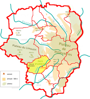
The Pays d'Uzerche is a traditional French landscape in the west of the Corrèze department . It is located in historic Limousin and is part of the Nouvelle-Aquitaine region .
geography
The Pays d'Uzerche, German landscape of Uzerche , surrounds the name-giving small town of Uzerche .
It is surrounded by the following natural spaces:
- the Pays de la Vienne in the north
- the Montagne limousine with the Massif des Monédières in the northeast
- the Pays de Tulle in the southeast
- the Briver Basin in the south
- the Nontronnais in the west
- the Plateau du Limousin in the north-west.
The western part of the Pays d'Uzerche consists of meadows and pastures that are mainly used for cattle breeding. The east is more forested. The settlements are quite scattered and larger municipalities besides Uzerche are Lubersac , Arnac-Pompadour and Vigeois . The landscape is the result of an ancient, pen-planed erosion plane, which moves between 300 and 500 meters above sea level. When you reach the Plateau de Millevaches you can even reach an altitude of 650 meters. Narrow and sometimes very deep river valleys have cut into the erosion plain, exposing what lies ahead.
Hydrography
The Pays d'Uzerche is drained roughly in the middle by the Vézère , which flows south-southwest towards the Dordogne . The Auvézère also flows along its west side , also in a south-westerly direction. The Pays de l'Auvézère , which represents the transition to the Nontronnais, is named after her .
geology
Geologically, the Pays d'Uzerche belongs entirely to the crystalline basement of the western Massif Central . Pending are mainly the amphibolite gneiss of the Upper Gneiss ceiling of the Limousin - mostly plagioklashaltige from former greywacke of the northern Gondwana margin emerged paragneisses . Occasional amphibolite bands and, very rarely, eclogites and their remains are embedded in the gneiss . The upper gneiss cover is folded east of Uzerche into a south-east striking synclinorium - the Uzerche synclinorium . In the north it is pushed under by the lower gneiss cover , which here has bulged into an anticlinorium - the Meuzac anticlinorium . In the south it borders the Greenschist Facial Thiviers-Payzac unit with a significant lateral displacement . In the east, the terran is separated from the arched parautochthonous Plateau de Millevaches by the north-south trending Argentat Fault - a cataclastic fracture zone several kilometers wide in places . In the west, the Massif du Vendômois is worth mentioning - an almost circular quartz diorite intrusion with a diameter of almost 10 kilometers, which is included in the Limousin tonalite line .
literature
- Frédéric Zégierman: Le Guide des Pays de France, Sud . Fayard, 1999.
- J.- P. Floc'h, P.- L. Guillot and D. Santallier: Uzerche - Vallée de la Vézère . In: Carte géologique de la France at 1/50 000 . BRGM, 1984.

