Grand Ried
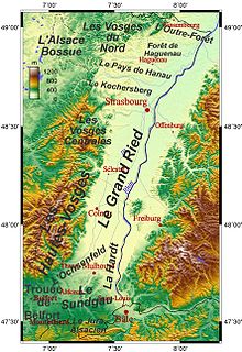
The Grand Ried , German: Großes Ried , is part of the Alsatian Ried . It stretches from Strasbourg in the north through Sélestat to Colmar in the south. In the west, the Grand Ried is bounded by the river Ill and in the east by the Rhine and was formed by the flooding of the two rivers. Nowadays the Rhine, wedged between dikes, can no longer spread the sediments, as it used to.
The municipality of Rhinau has a peculiarity: it owns almost 1000 hectares of real estate directly on the border, but on federal German territory: it is the municipality-free area of Rheinau . Numerous quarry ponds are in operation and thus shape the landscape of the Grand Ried. Which serves to regulate the flooding of the Rhine polder of Erstein is a national nature reserve since 1989th
Renewable energy
In Marckolsheim , Rhinau , Gerstheim and Strasbourg , the hydropower of the Rhine is used by France to generate electricity.
See also
Web links
- Grand Ried Tourist Office
- Landscapes of the Grand Ried (agence de développement et d'urbanisme de l'agglomération strasbourgeoise).
- Landscapes Communauté Urbaine de strasbourg Strasbourg city association
Individual evidence
- ↑ Grosses Ried and Illwald. In: elsass-netz.de. January 1, 2001, accessed February 15, 2014 .
- ↑ Axel Mayer: The Great Ried in Alsace: A fascinating natural landscape. In: vorort.bund.net. BUND , January 1, 2001, accessed February 15, 2014 .
- ^ Manfred Braunger: DuMont Reiseverlag (ed.): Alsace . books.google.de, January 1, 2001, ISBN 3770172221 , p. 288 (accessed February 15, 2014).
