Ork (Voerde)
|
Orc
City of Voerde (Niederrhein)
|
|
|---|---|
| Coordinates: 51 ° 35 ′ 46 ″ N , 6 ° 36 ′ 29 ″ E | |
| Height : | 22 m |
| Area : | 5.77 km² |
| Residents : | 390 (December 31, 2012) |
| Population density : | 68 inhabitants / km² |
| Incorporation : | 1922 |
| Postal code : | 46562 |
| Area code : | 02855 |
|
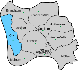
Location of Ork in Voerde (Niederrhein)
|
|
Ork is one of the younger districts of the city of Voerde (Lower Rhine) in the Wesel district , North Rhine-Westphalia and has approx. 390 inhabitants. Statistically, the district belongs to Spellen .
location
Ork is located seven kilometers west of the core town of Voerde on Landesstraße 4 directly on the Rhine . The district is bounded in the west by the Rhine (on the left bank of the Rhine is the Wallach district of the Rheinberg district of Borth ) in the north by Emmelsum , in the east by Spellen and Löhnen and in the south by Mehrum .
history
The Ork peasantry was never independent. The place belonged to the municipality Spellen until 1922 . Since 1815/16 Spellen has been part of the Götterswickerhamm mayor's office in the Dinslaken district , as have the municipalities of Voerde (Lower Rhine) , Mehrum , Görsicker , Möllen and Löhnen . The name of the mayor's office was changed to the mayor's office in Voerde in 1911 . Spellen was incorporated into Voerde together with Möllen in 1922. The Voerde mayor's office became the Voerde office in 1928. In 1950 the new municipality of Voerde was created through the union of the municipalities of Löhnen and Voerde. The district of Gest in the north of the district belongs to Ork.
Attractions
The small town is characterized by its location in the nature reserve Rhine foreland between Mehrum and Emmelsum . Within this is the dike cross on the Rhine dike , which was erected in 1996 and designed by the Voerder artist Julius Seifert. There is a memorial stone with a plaque on the cross. The ensemble commemorates Operation Plunder , which claimed many lives in March 1945 during the Second World War .
Web links
Individual evidence
- ^ Population of the city of Voerde. Retrieved April 1, 2013 .
- ^ Official Journal of the Düsseldorf Government 1911, p. 143
- ↑ Martin Bünermann, Heinz Köstering: The communities and districts after the municipal territorial reform in North Rhine-Westphalia . Deutscher Gemeindeverlag, Cologne 1975, ISBN 3-555-30092-X .
- ↑ Entry by Stefan Kronsbein on Deichkreuz bei Ork in the database " KuLaDig " of the Rhineland Regional Association , accessed on June 3, 2020.
- ↑ dike cross orc. Voerde.de, accessed on June 3, 2020 .

