Möllen (Voerde)
|
Möllen
City of Voerde (Niederrhein)
|
|
|---|---|
| Coordinates: 51 ° 34 ′ 54 ″ N , 6 ° 42 ′ 4 ″ E | |
| Height : | 27 m above sea level NHN |
| Area : | 6.4 km² |
| Residents : | 3040 (Dec. 31, 2014) |
| Population density : | 475 inhabitants / km² |
| Incorporation : | 1922 |
| Postal code : | 46562 |
| Area code : | 02855 |
|
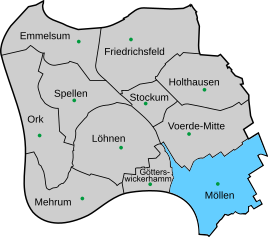
Location of Möllen in Voerde (Niederrhein)
|
|
Möllen is the southernmost district of the city of Voerde (Niederrhein) in the Wesel district , North Rhine-Westphalia and has 3040 inhabitants.
location
Möllen is separated from Dinslaken-Eppinghoven and -bruch by the residential forest. In the north are the city of Voerde and in the west Götterswickerhamm. The Rhine flows on the outskirts . The Tenderingssee lies between Hünxe and Möllen. At Tenderingssee there is a lido and a gravel pit.
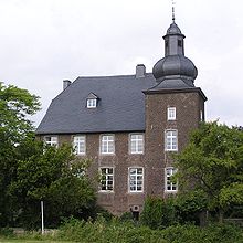
The Voerde power plant is a striking landmark of Möllen . Another landmark is the old moated castle " Haus Wohnung " owned by Steag-AG .
history
The Wasserburg Haus apartment was built in the 14th century. The former school was inaugurated in 1911. In 1912, the Möllen (Niederrhein) station on the Walsumbahn went into operation. The Evangelical Church was built between 1960 and 1965 and the Catholic Church of St. Barbara in 1963.
Others
- There is a Catholic and a Protestant day care center in the village .
- In Möllen there is a library that is run by the Förderverein Bücherei Möllen e. V. 1995 is directed.
- The local rainbow school is a community elementary school . There is also a special school .
- The DLRG local group Dinslaken eV maintains a Rhine rescue station in Möllen. It is located right next to the Voerde power plant.
Web links
Individual evidence
- ^ Heinrich Wuwer: 100 years of elevated railway. The railway line Oberhausen - Hamborn - Walsum - Möllen - Spellen - Wesel . Ed .: Heimatverein Voerde. Voerde 2013, p. 61-65 .


