Voerde (district)
|
Voerde-Mitte
City of Voerde (Niederrhein)
|
|
|---|---|
| Coordinates: 51 ° 36 ′ 0 ″ N , 6 ° 41 ′ 0 ″ E | |
| Height : | 26 m |
| Area : | 5.4 km² |
| Residents : | 16,043 (Dec. 31, 2014) |
| Population density : | 2,971 inhabitants / km² |
| Incorporation : | 1950 |
| Postal code : | 46562 |
| Area code : | 02855 |
|
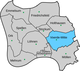
Location of Voerde-Mitte in Voerde (Niederrhein)
|
|
With Voerde the city is noisy main statutes Voerde (Niederrhein) in Wesel , North Rhine-Westphalia also meant the nucleus or Voerde-Mitte. Without the city districts of Stockum and Holthausen, which statically also belong to Voerde-Mitte, it has around 13,000 inhabitants. (As of December 31, 2012)
location
The Voerde district lies in the east of the city of Voerde between Bundesstraße 8 in the east and Landesstraße 396 in the west; the circuit road 17 runs in a north-south direction by the district. The district is bounded in the west by Löhnen , in the north by Stockum and Holthausen , in the east by Hünxe-Bruckhausen , in the south by Möllen and in the south-west by Götterswickerhamm .
For more see main article Voerde (Niederrhein)
Individual evidence
- ^ Population of the city of Voerde. Retrieved April 1, 2013 .
- ↑ Martin Bünermann, Heinz Köstering: The communities and districts after the municipal territorial reform in North Rhine-Westphalia . Deutscher Gemeindeverlag, Cologne 1975, ISBN 3-555-30092-X .

