
Spellen
|
Spellen
City of Voerde (Niederrhein)
|
|
|---|---|
 |
|
| Height : | 26 m |
| Area : | 4.4 km² |
| Residents : | 4539 (December 31, 2018) |
| Population density : | 1,032 inhabitants / km² |
| Incorporation : | 1922 |
| Postal code : | 46562 |
| Area code : | 02855 |
 Location of Spellen in Voerde (Niederrhein)
|
|
Spellen is the oldest part of the city of Voerde (Niederrhein) on the Lower Rhine in the Wesel district in North Rhine-Westphalia and has 4,539 inhabitants.
Spellen was first mentioned in a document in 777 in the golden book of Echternach Abbey. There it says "in the Gau Spellen, where the Lippe flows into the Rhine". A special architectural monument of the place is the Catholic Church of St. Peter , whose parish can look back on more than 1200 years of history. The bell tower of the Protestant church (white exterior) was not rebuilt after it was destroyed in World War II , it is only 15 meters high today.
In 2000 the village square was rebuilt. In addition to various shops, there is now also a facility for disabled people. Spellen also owns a retirement home with adjoining houses for senior-friendly living.
The municipality of Spellen, together with the farmers Emmelsum, Gest, Mehrum and Ork, became part of the then municipality and today's city of Voerde in the course of the municipal reform in 1922. The Spellen station was on the Oberhausen – Walsum – Wesel railway (Walsumbahn) .
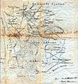
Map from 1898

Spellen village center - aerial view 2005

Evangelical Church Spellen


literature
- Wilhelm Kolks: Where the church tower of Sankt Peter ... traces of Spellen's history . Parish of St. Peter, Voerde-Spellen 1999
Web links
Individual evidence
- ^ City of Voerde (Niederrhein): Population of the city of Voerde (Niederrhein) as of December 31, 2018 | City of Voerde (Lower Rhine). Retrieved December 10, 2019 .
Emmelsum | Friedrichsfeld | Götterswickerhamm | Holthausen | Wages | Mehrum | Möllen | Orc | Spellen | Stockum | Voerde