Faschinajoch
| Faschinajoch | |||
|---|---|---|---|
|
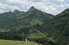
View from the Glatthorn to the Faschinajoch |
|||
| Compass direction | east | west | |
| Pass height | 1486 m above sea level A. | ||
| state | Vorarlberg ( Austria ) | ||
| Watershed | Lutz → Ill → Rhine | Argenbach → Bregenz Ach → Rhine | |
| Valley locations | Faschina , Fontanella ( Großes Walsertal ) | Damuls | |
| expansion | L 193 (Faschina Street) | ||
| Built | Opened in 1985 | ||
| Lock | - | ||
| Mountains | Bregenz Forest Mountains , Lechquellen Mountains | ||
| map | |||
|
|
|||
| Coordinates | 47 ° 16 '19 " N , 9 ° 54' 27" E | ||

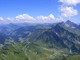
The Faschinajoch is a mountain pass in the Alps ( Eastern Alps , Northern Limestone Alps ) at 1486 m above sea level . It is located in the Austrian state of Vorarlberg and connects the valley of the Bregenzer Ach ( Bregenz Forest ) near Damüls with the valley of the Lutz ( Großes Walsertal ) near Faschina .
Faschina Straße (formerly Bundesstraße 193, now L 193) leads over the pass, which is well-developed and winter-proof . The eastern part of the route is very popular with motorcyclists .
The Faschinajoch gets its name from 'Fassia', which means 'a strip of meadow'. This is first mentioned in a document as 'Vaschin' in 1482. At that time, most of the alpine pastures were already in use on the crossing; It is reported from later years that a house stood on the top of the pass, which was continuously occupied not only in summer but also in winter. A small chapel dedicated to Holy Mother Anna was also attached to this house.
Web links
Individual evidence
- ↑ ÖK50 in: www.austrianmap.at , Federal Office for Metrology and Surveying Austria, Austrian map.
- ^ Steffan Bruns: Alpine passes . The passes on both sides of the Brenner route. tape 1 . L. Staackmann Verlag, Munich 2010, ISBN 978-3-88675-256-0 , p. 28 .

