
Ill (Vorarlberg)
| Ill | ||
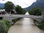
 Ill near Feldkirch-Gisingen |
||
| Data | ||
| Water code | AT : 8122 | |
| location | Vorarlberg , Austria | |
| River system | Rhine | |
| Drain over | Rhine → North Sea | |
| source |
Silvretta ( Ochsentaler Glacier ) 46 ° 52 ′ 9 ″ N , 10 ° 6 ′ 32 ″ E |
|
| Source height | approx. 2240 m above sea level A. | |
| muzzle |
Alpine Rhine near Meiningen Coordinates: 47 ° 17 '57 " N , 9 ° 33' 31" E 47 ° 17 '57 " N , 9 ° 33' 31" E |
|
| Mouth height | 429 m above sea level A. | |
| Height difference | approx. 1811 m | |
| Bottom slope | approx. 24 ‰ | |
| length | 75.3 km | |
| Catchment area | 1281 km² | |
| Discharge at the Gisingen gauge (A Eo :) A Eo : 1,425.5 km² Location: 4.39 km above the mouth |
NNQ (01.01.2005) MNQ 1971–2010 MQ 1971–2010 Mq 1971–2010 MHQ 1971–2010 HHQ (23.08.2005) |
3.58 m³ / s 14.9 m³ / s 65.5 m³ / s 45.9 l / (s km²) 320 m³ / s 689 m³ / s |
| Small towns | Feldkirch , Bludenz | |
|
Tributaries and hydraulic structures
|
|||||||||||||||||||||||||||||||||||||||||||||||||||||||||||||||||||||||||||||||||||||||||||||||||||||||||||||||||||||||||||||||||||||||
The Ill on the right bank of the Rhine is just over 75 kilometers long and is located entirely in the Austrian state of Vorarlberg . With an average water flow of 65.5 m³ / s, it is the largest tributary of the Alpine Rhine .
Origin of name
The name of the Ill is of Celtic origin. It comes from the word ilara for "in a hurry". The first documentary mention was made in 1377 as Yll .
Source and history
The headwaters of the Ill are the Alps in the Silvretta group . It is located at the foot of Dreiländerspitze (3197 m), Piz Buin (3312 m) and Silvrettahorn (3244 m) in the Ochsental at an altitude of about 2240 m above sea level. A.
Three glaciers feed the young Ill with their runoff: Vermunt glacier, Ochsental glacier and snow bell glacier . The discharge of the Ochsental Glacier is called the Ill source. Then the Ill flows through the Ochsental and is dammed up to the Silvretta reservoir . The water from the Tyrolean Bieltalbach is fed into these.
In the further course it flows through the Montafon and the Walgau and flows into the Rhine below Feldkirch between Nofels ( Matschels ) and Meiningen at an altitude of 429 meters at the newly designed so-called Illspitz .
Tributaries
The first tributary is the Klostertalbach , which flows from the Klostertal , fed by the Klostertaler glacier , into the Silvretta reservoir. A smaller tributary, but still important, is the Balbierbach in Gortipohl. The longest tributary (24 km) is the Litz , which flows into the Ill near Schruns .
Follow on to larger tributaries of the River Ill Bludenz the Alfenz which Alvierbach and opens from left Schesa ( Schesatobel ), a torrent that for about 200 years the settlement area and the roads in the area of Bludenz and Bürs threatened.
Other major tributaries are the Alvier, the Lutz between Nenzing and Nüziders , the Meng and the Samina near Frastanz .
Hydropower plants
illwerke vkw
In the catchment area of the river there are several barrages and pumped storage power plants from illwerke vkw AG , which mostly supply peak electricity - also for export: Vermuntwerk , Kops , Silvrettasee , Lünersee , and the Latschau reservoir .
The Walgau plant in Nenzing was put into operation in 1984. It uses the difference in gradient along the Ill to Latschau and Tschagguns .
Stadtwerke Feldkirch
The Hochwuhr river power plant above the Ganahl area in Feldkirch is operated by the Feldkirch municipal utility .
various
- In 1953, in Vienna-Floridsdorf , Illgasse was named after the river.
- Another tributary of the Rhine called Ill can be found in Alsace . It is three times the length of the Vorarlberger Ill, but it has less water.
photos

Ill origin from the high wheel

Illspitz near Feldkirch

Illspitz near Feldkirch , 2008, with a new bridge
Listed bridge between Bludenz and Bürs

Confluence with the Silvretta reservoir
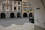
High water mark of the Ill from June 15, 1910 in an arcade on the market square in Feldkirch


_-_Marktplatz,_Hochwassermarke_15.06.1910_(01-2).JPG)
Web links
References and comments
- ↑ Vorarlberg Atlas
- ↑ Gisingen gauge ( Memento of the original from November 22, 2011 in the Internet Archive ) Info: The archive link was inserted automatically and has not yet been checked. Please check the original and archive link according to the instructions and then remove this notice.
- ↑ Federal Ministry of Agriculture, Forestry, Environment and Water Management (ed.): Hydrographisches Jahrbuch von Österreich 2010. 118th volume. Vienna 2012, p. OG 72, PDF (12.6 MB) on bmlrt.gv.at (yearbook 2010)
- ↑ Note: The hydrologically effective catchment area has been artificially enlarged by 144.5 km² due to inflows and outflows (from illwerke vkw AG ) from neighboring catchment areas. ( Hydrographic Yearbook of Austria 2010 , p. OG 72)
- ↑ Exact value not known, stated value is a minimum value (can be up to 19 meters higher). It was determined from the distance between the contour lines (20 meters in altitude ) on a topographic map ( scale 1: 25,000).
- ↑ a b Federal Office for Metrology and Surveying Austria: Austrian Map online , accessed on May 12, 2010.
- ↑ Robert Kirnbauer: Precipitation-runoff simulation for hazard zone plans - Schesatobel case study near Bludenz ( Memento of the original from August 26, 2016 in the Internet Archive ) Info: The archive link was inserted automatically and has not yet been checked. Please check the original and archive link according to the instructions and then remove this notice. . In: Wiener Mitteilungen: Precipitation-runoff modeling - simulation and prognosis . Volume 164 (PDF; 1.1 MB), accessed on November 11, 2012.
- ↑ Stadtwerke Feldkirch: Hochwuhr power plant , accessed on December 3, 2015.