
Silvrettahorn
| Silvrettahorn | ||
|---|---|---|
 Silvrettahorn from the north |
||
| height | 3244 m above sea level M. | |
| location | Graubünden , Switzerland / Vorarlberg , Austria | |
| Mountains | Silvretta | |
| Dominance | 2.3 km → Kleiner Piz Buin | |
| Notch height | 201 m ↓ Fuorcla dal Cunfin | |
| Coordinates , ( CH ) | 46 ° 51 '25 " N , 10 ° 5' 35" O ( 802386 / 192958 ) | |
|
||
| First ascent | 1865 by Jules Jacot with two guides | |

The Silvrettahorn ( 3244 m ) is a glaciated mountain peak of the Silvretta group in the Eastern Alps.
Location and surroundings
The border between Switzerland (Canton of Graubünden ) and Austria (state of Vorarlberg ) runs over the summit . The Silvrettahorn with its neighboring peaks is bordered in the east and northeast by the Ochsental (source valley of the Ill ) with the 2 km long Ochsental glacier , in the northwest by the Klostertal and in the south by the Silvretta glacier .
The direct neighboring peaks of the Silvrettahorn include the knot (3189 m) as well as the peaks of the Schneeglocke ( 3223 m above sea level ), Schattenspitze ( 3202 m above sea level ) and the Klostertaler Egghorn ( 3120 m above sea level ), which are entirely on Austrian soil . A. ). Over the ridge extending to the west with the Rotfluh ( 3166 m above sea level ) as well as via the southeastern peaks of the Silvretta-Egghorn (3147 m) and the Signalhorn ( 3207 m above sea level , according to BEV 3210 m above sea level). ) runs the state border.
geology
The geological structure of the Silvrettahorn is relatively complicated. It is part of the Silvretta cover, which forms the highest tectonic unit of the alpine cover in the area of the Silvretta group. Parts of the crystalline bedrock came under very high pressure during the formation of the Alps, which led to the metamorphosis of the rock. That is why you can find mica-rich gneisses in the area today , which alternate with light granite and amphibolite .
Ascent
The Silvrettahorn was first climbed in 1865 by Jules Jacot with two guides . Starting points for the ascent today are the Wiesbadener Hütte ( 2433 m above sea level ) in the Ochsental and the Klostertaler Umwelthütte on the Austrian side and the Silvrettahütte of the Swiss Alpine Club SAC at 2341 m above sea level on the Swiss side . M. and the Tuoi hut , from which the Silvrettahorn can be climbed over the Fuorcla dal Cunfin and the Ochsentaler glacier .
view
The view from the Silvrettahorn is only limited by a few higher mountains in the vicinity and extends particularly far to the southwest and west; to Monte Rosa (200 km) and the Lyskamm behind it (203 km), to the Weißhorn (202 km) and to the Bernese Alps with the Aletschhorn (166 km), Finsteraarhorn , Mönch and other well-known peaks. Sometimes the view extends over the main Alpine ridge , for example to Care Alto and Monte Disgrazia . You can also see (from east to south to west), for example, Zugspitze , Zuckerhütl , the Ötztal Alps , Ortler group , Presanella , Adamello , Bernina , Pizzo Tambo , Rheinwaldhorn , Dammastock and Tödi . If the haze permits, you can also look very far into Baden-Württemberg , up to Belchen in the Black Forest , 202 km away , to Braunhörnle (1134 m, 206 km) or to the Dreifürstenstein 240 km away on the Swabian Alb .

Winter ascent to the Silvrettahorn

Silvrettahorn from the east, from the Grüner Kuppe
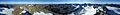
360 ° panoramic view from the Silvrettahorn


Web links
Individual evidence
- ↑ PeakFinder Ltd [email protected]: mountain panorama: silvrettahorn. Retrieved March 16, 2020 .