
Wiesbadener Hut
| Wiesbadener hut DAV hut category I. |
||
|---|---|---|
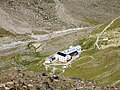
 The Wiesbadener hut with the Piz Buin |
||
| location | at the foot of Piz Buin ; Vorarlberg , Austria ; Valley location: Partenen | |
| Mountain range | Silvretta | |
| Geographical location: | 46 ° 52 '5 " N , 10 ° 6' 57" E | |
| Altitude | 2443 m above sea level A. | |
|
||
| owner | Section Wiesbaden of the DAV | |
| Construction type | Hut; stone | |
| Development | Summer: jeep, winter: helicopter, snowmobile | |
| Usual opening times | Mid-February to late April, late June to early October | |
| accommodation | 80 beds, 100 camps | |
| Winter room | 20 bearings | |
| Web link | Wiesbadener Hut | |
| Hut directory | ÖAV DAV | |

The Wiesbadener hut is an alpine club hut in the Silvretta in Vorarlberg ( Austria ).
location
The 1st category alpine refuge is located at 2,443 m above sea level. A. in Ochsental at the foot of Piz Buin and belongs to the Wiesbaden section of the German Alpine Club .
Wiesbadener Hut from the path to the Tiroler Scharte

The shadow of the Silvrettahorn has just passed over the Alpine Club House

View from the Klostertaler Egghorn (3120 m) to the Alpine Club House.


Approaches
All approaches to the hut start on the Bielerhöhe ( 2037 m ), which can be reached in summer by car and buses from the Montafon and the Paznaun Valley via the Silvretta High Alpine Road (L 188). In winter, when the road is closed to public traffic, you can get there from Partenen in the Montafon with the help of the Vermunt cable car and subsequent transfer in minibuses.
- On a cart path on the orographic left side of the Silvretta reservoir and through the Ochsental . Walking time 2 - 2½ hours.
- On a trail (white-blue marking) above the reservoir. Surefootedness required, walking time 2½ hours.
- Through the Bielertal and over the Radsattel. Walking time 3 hours.
Since the commissioning of the Obervermuntwerk II , winter access via the previously completely frozen Lake Silvrettasee has been difficult. As a result of the intensive extraction and supply of water through the plant, the lake in the northern part remains free of ice and can be bypassed there via the two western dams and a tunnel drilled during the construction of the plant. A longer, but less avalanche-prone access leads through the Bieltal and over the Radsattel (2652 m).
Tour possibilities
- Piz Buin ( 3312 m ). Walking time 3 - 4 hours.
- Silvrettahorn ( 3244 m ). Walking time 3 - 3½ hours.
- Dreiländerspitze ( 3197 m ). Walking time 2½ - 3 hours.
- High bike ( 2934 m ). Walking time 2½ hours
- Vermuntkopf ( 2851 m ). Walking time 1½ hours
Neighboring huts
- To the Madlenerhaus ( 1986 m ) over the Bielerhöhe. Walking time 2½ hours.
- Over the Vermunt Pass to the Tuoi Hut . Walking time 2½ - 3 hours.
- Via the Obere Ochsenscharte ( 2970 m ) to the Jamtalhütte . Walking time 3½ - 4 hours.
- To the Saarbrücker Hütte via Fuorcla dal Confin, Rotfurka, Winterlücke and Litznersattel. Walking time 6 - 7 hours.
- To the Klostertaler Umwelthütte . Walking time 2 hours

cards
- Alpine Club Card 26 Silvretta Group (1: 25,000)
literature
- Günter Flaig: Silvretta, Alpine Club Guide alpin , Bergverlag Rudolf Rother , Munich 2005, ISBN 978-3-7633-1097-5
Web links
- Section Wiesbaden in the DAV
- Your mountains: Wiesbadener Hütte - mountaineering & hiking portal
Individual evidence

Cadastral communities: Gaschurn • Localities and counting districts: Gaschurn | Partenen
Villages:
Gaschurn •
Rotten:
Auserbach |
Outside sofa |
Aussergosta |
Bielerhöhe |
Gufelgut |
Gundalatscherberg |
Inner bofa |
Innergosta |
Hole |
Motta |
Partenen |
Catches |
Pfolla |
Rifa |
Trantrauas |
Vand |
Angle |
Zeinisjoch •
Other settlements:
Heilbronner Hütte |
Klostertaler Hut |
Madlenerhaus |
Rifawerk |
Saarbrücker Hut |
Tübinger Hut |
Alpe Valschaviel |
Wiesbadener Hut |
Zeinisjochhaus