High wheel (Silvretta)
| High wheel | ||
|---|---|---|
|
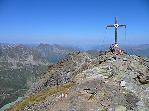
View from the south of the Hohe Rad |
||
| height | 2934 m above sea level A. | |
| location | Vorarlberg and Tyrol , Austria | |
| Mountains | Silvretta | |
| Dominance | 2.5 km → Madlenerspitze | |
| Notch height | 282 m ↓ saddle | |
| Coordinates | 46 ° 53 '32 " N , 10 ° 6' 42" E | |
|
|
||
|
Summit with Silvretta reservoir (bottom left) |
||
The high wheel is 2934 m above sea level. A. high mountain in the Silvretta group on the border between Vorarlberg and Tyrol . The mountain lies on the banks of the Silvretta reservoir near Bielerhöhe (2,035 m).
The summit can be reached from the Bielerhöhe either through the Ochsental or the Bieltal . On Radsattel ( 2652 m ) meet both increases, the summit slope is easily exposed and requires surefootedness . There is also a shorter climb from the north, which branches off a little below the Bielerdamm from the path through the Bieltal to the south (there is a signpost), winds steeply over the north ridge of the Hohen Rad and at the Radschulter ( 2697 m. Template: height / unknown referenceAbove sea level ) meets the path coming from the saddle.
The Radsee ( 2477 m above sea levelTemplate: height / unknown reference ) is embedded in a high trough between the summit and the Bieltal .
literature
- Johannes Frischauf : The high wheel 2912 m. In: Journal of the German Alpine Association / Journal of the German and (the) Austrian Alpine Association , year 1888, (Volume XIX), pp. 238–242. (Online at ANNO ). .
Web links
Individual evidence
- ↑ Alpine Club Map No. 26 "Silvrettagruppe" (ski tour map), 9th edition 2013, ISBN 978-3-928777-37-7 .


