
Bielerhöhe
| Bielerhöhe | |||
|---|---|---|---|
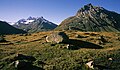
 Silvretta reservoir on the Bielerhöhe, view to the south |
|||
| Compass direction | west | east | |
| Pass height | 2037 m above sea level A. | ||
| state | Vorarlberg , Austria | Tyrol , Austria | |
| Watershed | Ill , Rhine | Vermunt , Trisanna , Inn ( Danube ) | |
| Valley locations | Partenen | Galtür | |
| expansion | Road (toll) | ||
| Winter closure | November to April | ||
| Mountains | Silvretta | ||
| map | |||
|
|||
| Coordinates | 46 ° 55 '5 " N , 10 ° 5' 44" E | ||

The Bielerhöhe connects the Vorarlberg Montafon with the Tyrolean Paznaun . The pass is at 2037 m above sea level. A. directly north of the Silvretta reservoir and entirely in the Vorarlberg area. The Bielerhöhe is the highest accessible point on the Silvretta-Hochalpenstraße , a toll road over the Bielerhöhe, which is closed to normal traffic in winter (November to April) due to its exposed location. However, you can then reach the top of the pass from Partenen (Vorarlberg) via the Vermuntbahn and a tunnel of the illwerke vkw AG as well as the last part of the usual pass road as part of a taxi service.
geography
Location and landscape
The Bielerhöhe lies on the watershed between the Rhine and the Danube . The whole valley on both sides of the Bielerhöhe is called Vermunt , the Großvermunt and Schweizervermunt - at today's Vermuntsee - on Vorarlberger, the Kleinvermunt on the Tyrolean side. The former form the upper valley of the Ill (to the Rhine), in the latter the Vermunthbach flows to Trisanna and the Inn. The top of the pass is in Vorarlberg. The state border runs further east and over the Zeinisjoch .
The dominant part of the Bielerhöhe is the Silvretta reservoir , in which the lower Ochsental , which branches off to the south towards the Piz Buin , has drowned. In order to control the water flow of the Ill, the lake was pulled out of the Ochsental up to the top of the pass. The lake is secured with dams in both directions.
Under Bielerhoehe refers to both whole about two kilometers relatively flat pass scenery between the two steep climbs as well as the small elevation on the north edge of the pass ( 2071.9 m above sea level. A. ⊙ about them is a walking), as well as the Saddle height of the road itself ( 2037 m above sea level ). The original Bielerhöhe ( 2021 m above sea level. A. ⊙ ) is also gone under the dam.
North of the Bielerhöhe is the Bielerspitze ( 2545 m above sea level ) of the Vallülagruppe (Nordsilvretta), in the south Hohes Rad ( 2934 m above sea level ) and the Lobspitzen (rear Lobspitze 2873 m above sea level ), and between the two distant but dominating, the Piz Buin massif .
The settlement of Bielerhöhe
In the area of the pass there are inns and hotels as well as the Madlenerhaus , a base of the German Alpine Association . The Bielerhöhe / Silvrettahaus base , which was built in 1991/92 by Vorarlberger Illwerke and is also used as a hotel, is architecturally interesting . The little mountain church Barbarakapelle on the Bielerhöhe of the illwerke vkw comes from the power plant construction activities of the 1960s: It was built between 1965 and 1967 for the deceased construction workers of the power plant construction, is consecrated to the patron saint of the mining engineers and represents the place of worship of the settlement.
| Bielerhöhe ( Rotte ) | |
|---|---|
| Basic data | |
| Pole. District , state | Bludenz (BZ), Vorarlberg |
| Judicial district | Bludenz |
| Pole. local community | Gaschurn ( KG Gaschurn) |
| Locality | Partenen |
| Coordinates | 46 ° 55 ′ 5 " N , 10 ° 5 ′ 43" E |
| height | 2037 m above sea level A. |
| Post Code | 6794 Partenen |
| Statistical identification | |
| Counting district / district | Partenen (80 110 001) |

|
|
| Source: STAT : index of places ; BEV : GEONAM ; VoGIS | |
Development
Silvrettasee
The Silvretta reservoir , the highest in the Obere Ill-Lünersee power plant group, was built right at the top of the pass . The Ill rises south of the top of the pass, in the vicinity of which it occasionally changed its direction of flow, so that instead of flowing west into the Rhine, sometimes east into the Inn. The reservoir put an end to it, it not only dammed the Ill, its two dams now also clearly regulate the Ill flow.
Originally built just for the power plant, it has become a popular tourist destination. Today the seascape is also a fishing area. (No. 132). A special feature is a boat tour with the Silvretta motorboat , Europe's only regular motorboat service at over 2000 m above sea level. However, this feature cannot be used at the moment. The boat traffic was stopped in the 2011 season due to a technical defect and has not been resumed since then.
The summit of the Silvretta High Alpine Road
In 1953 the power plant builders built the Silvretta High Alpine Road between Partenen and Galtür. This leads high above the actual pass, as the reservoir blocks it. Originally just Baustraße, today it is a toll part of B / L 188 Paznauner Straße / Montafoner Straße Pians - Bludenz . This responded to the unexpected interest in the route, which is insignificant in terms of transit traffic but is in demand as a tourist destination.
On the west ramp, the road has to overcome 700 vertical meters in a straight line distance of just three kilometers to the Vermunt reservoir. This was made possible by stretching the road over 25 hairpin bends over nine kilometers and thus stretching the incline to the maximum extent possible. From the dam of the Vermunt reservoir, the top of the pass can be reached relatively easily via a few hairpin bends. In contrast to the west ramp, the east ramp could be built without bends and is therefore much easier to drive on.
Winter sports area Silvretta – Bielerhöhe
There is also a small winter sports area on the Bielerhöhe . It is set up for a relaxing holiday as a target group, has only a short practice lift (“Silvrettasee” drag lift, up to 2042 m above sea level ) and a few kilometers of cross-country ski run. Although the winter closure is imposed over the Silvrettastraße, the ski area is accessible: Access is via the Vermuntbahn Partenen - "Tromenier" ( 1731 m above sea level ), and from there with the shuttle bus on the old, winter-safe construction road through tunnel and the Vermuntsee the Bielerhöhe. As a result, the area has around two kilometers of slopes, because you can take the bus route with the possibility of returning. The Golm Silvretta Lünersee Tourismus GmbH , the operating company of illwerke vkw AG, offers both ski lifts and bus as experience Silvretta Bielerhöhe at ticket. Pistenbulli-Jöring is possible from Galtür to the top.
In addition, the whole area forms the largest touring area in Vorarlberg, extending deep into the entire central and northern Silvretta. The accommodation facilities are expressly set up for ski tourers and offer not only accommodation, but also changing facilities and lockers for day trips (Berggasthof Piz Buin). This is a special feature throughout Austria , since ski tourers are usually not very welcome in ski areas: Golm Silvretta Lünersee Tourismus markets the area as a “cross-country and touring paradise”.
gallery

part of the natural Bielerhöhe

East bank of the lake share with the settlement "Bielerhöhe"

" Vermuntalm / Großvermunt ", outflow of the Ill to the west to the Obervermuntwerk

Panorama between Bielerhöhe and Wirl


Web links
- www.silvretta-bielerhoehe.at - Golm Silvretta Lünersee Tourism
Individual evidence
- ↑ ÖK50 in: www.austrianmap.at , Federal Office for Metrology and Surveying Austria, Austrian map.
- ↑ “Bielerhöhe is used to designate two landscape areas: the pass and hilly landscape of the same name or its highest point, 2071 m, north of the N edge of Lake Silvretta. It also means the road pass itself, at 2032 m the highest point on the Silvretta High Alpine Road. ”Walther Flaig, Günther Flaig: Silvretta . 13th edition. Rother Bergverlag, Munich 2005, ISBN 978-3-7633-1097-5 , 801 Bielerhöhe, 2071 m, p. 275 ( rother.de ; limited preview in the Google book search).
- ↑ Corner of the state border, information on f & b hiking map, sheet 37 Rhätikon-Silvretta group 1: 100,000, approx. 1960s
- ↑ Bielerhöhe / Silvrettahaus base of Vorarlberger Illwerke AG , nextroom.at (architecture database)
- ↑ Silvrettasee ( Memento from March 5, 2016 in the Internet Archive ). Illwerke sport fishing club
- ↑ Silvretta Hochalpenstraße / Silvretta Bielerhöhe ( Memento from July 6, 2012 in the Internet Archive )
- ^ Motorboat Silvretta - summer 2011. Illwerke Seilbahn Betriebsges.mbH, accessed on 23 August 2012 .
- ↑ Summer 2012 - Silvrettasee motorboat out of service! Illwerke Seilbahn Betriebsges.mbH, accessed on August 23, 2012 .
- ^ Steffan Bruns: Alpine passes. The passes between Lake Constance and Lake Como . tape 2 . L. Staackmann Verlag, Munich 2010, ISBN 978-3-88675-281-2 .
- ↑ Silvretta-Bielerhöhe Winter , silvretta-bielerhoehe.at
- ↑ a b c d Silvretta Bielerhöhe - Gaschurn Partenen 1,030–2,042m . 'bergfex.at - with a piste map
- ↑ a b gsl-tourismus.at
Ahorn • Alpl • Ammer • Annaberg • Arlberg • Ascher • Bieler • Birkfelder • Boding • Brenner • Buchauer • Buchener • Dientner • Dürrholzer • Eibegg • Erb • Eisental • Faschina • Feistritz • Fern • Filzen • Flattnitz • Flexen • Forsthof • Furka • Fuscher • Gaberl • Gaden wide • Gailberg • Gangleit • Geiseben • Gerichtsberg • Gerlos • Geschriebenstein • Goller • Grießen • Griffner • Large Kripp • Grubberg • Grünbacher • Gschuett • Hafner • Hahntenn • neck • Haselrast • Hebalm • stallion • Hengstl • Hiaslegg • Hirschegger • Hochegger • Hochrindl • Hochtannberg • Hochtor • Holzleiten • Iselsberg • Josefsberg • Kaiserauer • Cold Kuchl • Kartitscher • Katsch • Kernhofer • Kerschbaumer • Klachauer • Klamm • Klamml • Small Kripp • Klippitz • Klostertaler • Kraxen • Kreuth • Kreuzberg • Kühtai • Lahn • Lienbach • Loibl • Losen • Luft • Mendling • Michelbühel • Moarigraben • Nassfeld • Neumarkter • Niederalpl • Norberts • Nöring • Obdacher • Oberjoch • Och • Pack • Paulitsch • Perchauer • Pfaffen • Pfarralm • Pielachtaler • Piller • Plöcken • Pogusch • Pölshals • Pötschen • Präbichl • Prebersattel • Preiner • Pretal • Promau • Pyhrn • Radl • Radling • Radstädter • Radstatt • Rams • Raneck • Rechberg • Rieder • Rohrer • Sattler • Saurüssel • Schaida • Schanz • Scharflinger • Schiestel • Schober • Schönfeld • Schwarze Sau • Schwarzenbichl • Seeberg • Seefelder • Semmering • Kleiner Semmering • Sieggraben • Silzer • Soboth • Summer • Staller • Styrian Seeberg • Straßegg • Sölk • Thurn • Timmels • Triebener Tauern • Turracher • Origin • Wechsel • Weinebene • Weißenbacher • Wagrainer • Windische • Wurzen • Zellerrain

Cadastral communities: Gaschurn • Localities and counting districts: Gaschurn | Partenen
Villages:
Gaschurn •
Rotten:
Auserbach |
Outside sofa |
Aussergosta |
Bielerhöhe |
Gufelgut |
Gundalatscherberg |
Inner bofa |
Innergosta |
Hole |
Motta |
Partenen |
Catches |
Pfolla |
Rifa |
Trantrauas |
Vand |
Angle |
Zeinisjoch •
Other settlements:
Heilbronner Hütte |
Klostertaler Hut |
Madlenerhaus |
Rifawerk |
Saarbrücker Hut |
Tübinger Hut |
Alpe Valschaviel |
Wiesbadener Hut |
Zeinisjochhaus