Tips of praise
| Tips of praise | |
|---|---|
|
The praise from the east |
|
| Highest peak | Hintere Lobspitze ( 2873 m above sea level ) |
| location | Gaschurn , Vorarlberg , Austria |
| part of | Litzner-Sehörner-Gruppe , Westsilvretta (to Flaig), Silvretta , Eastern Alps |
| Coordinates | 46 ° 53 '42 " N , 10 ° 3' 29" E |
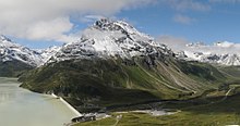
The Lobspitzen are the mountain ridge that branches off from the main ridge of the Silvretta , on the Vorarlbergisch - Grisons border, on the Großlitzner ( 3108 m above sea level ) to the north into the Montafon . That is why they are placed by Günter Flaig , the author of the Alpine Club Guide for the Silvretta group, in the Litzner-Seehorner group , which is part of the Westsilvretta .
The ridge stretches from the Litznersattel ( 2737 m above sea level ) to the northeast, the Klostertal and then the Ochsental on the right, and the Swiss Vermunt (the valley of the Kromerbach ) on the left. The Ochsental is the source valley of the Ill , the main river of the Montafon. It runs to the Bieler Höhe , the Vorarlberg / Tyrol pass crossing ( 2037 m above sea level ), with the Silvrettasee , which occupies the lowest Ochsental. There the Ill swings westward, forms the northern limit of the Lobspitzen in Großvermunt , the Passhochtal of the Bielerhöhe, and takes in the Kromerbach in Vermunt in Switzerland, from where it flows primarily north again.
The lobes themselves are a sequence of the following peaks:
- Hintere Lobspitze ( 2873 m above sea level )
- Lobturm ( 2867 m above sea level )
- Middle Lobspitze ( 2799 m above sea level )
- Vordere Lobspitze ( 2837 m above sea level )
- Kleine Lobspitze ( 2760 m above sea level )
Then the ridge drops in a mighty flank without any further summit towards Silvrettasee and Großvermunt.
Directly on the Litznersattel there are three more peaks that can be counted among the Lobspitzen or not:
- Verhupfspitze ( 2957 m above sea level ), looks southeast into the Klostertal and the Verhupftäli (to the Litznersattel)
- Sattelkopf ( 2863 m above sea level ), directly on the saddle
- Glötterspitze ( 2837 m above sea level ), towards the northwest, on the Litzner glacier
The mountains are unmarked, difficult alpine terrain. Around the group are the Bielerhöhe with the Piz Buin mountain inn (private), the Klostertaler Hütte (DAV), and the Saarbrücker Hütte (DAV). Only the slight circuit around Bielerhöhe - Klostertal - Litznersattel - Saarbrücker Hütte - and back via Tschifernella (last stage part of Zentralalpenweg 02) is marked.
The area is largely natural and was designated in the Vorarlberg biotope inventory as a large alpine biotope of the Klostertal (No. 11023), which comprises 1286.9 hectares in the Klostertal and the entire Lobspitz group; but it is not under any special nature protection. Special features are the occurrence of ibex , which has been reintroduced there in recent years, and rare plant species such as Allermann's armor ( Allium victorialis ), Alpine man's shield ( Androsace alpina ), real rue ( Artemisia umbelliformis syn.mutellina ) or Swiss willow ( Salix helvetica ) .
literature
- Günter Flaig: Silvretta, Alpine Club Guide alpine . Bergverlag Rudolf Rother , Munich 2005, ISBN 978-3-7633-1097-5 , Litzner-Seehörner-Gruppe , p. 159 ff; Hütten p. 129 ff
Web links
Individual evidence
- ^ Markus Staudinger, AVL Arge Vegetation Ecology and Landscape Planning: Gaschurn . Community report. In: Georg Grabherr; Vorarlberg Landscape Conservation Fund; Vorarlberger Landesregierung - Department of Environmental Protection IVe (Ed.): Biotopinventar Vorarlberg . Vorarlberger Verlagsanstalt, Bregenz June 2008, Alpine large-scale biotope of the Valülatäler (biotope 11023) , p. 42 f . ( PDF , vorarlberg.at; online , VOGIS - 1st recording of the Montafon inventory. 1984.).


