
Silvretta reservoir
| Silvretta reservoir | ||
|---|---|---|

|
||
|
Silvretta reservoir from the Bielerspitze (view to the south) |
||
| Geographical location | Vorarlberg , Austria | |
| Tributaries | Ill , Klostertaler Bach, Bieltalbach | |
| Drain | Ill, tunnel to the [[ Obervermuntwerke ]] | |
| Data | ||
| Coordinates | 46 ° 54 '27 " N , 10 ° 5' 35" E | |
|
||
| Altitude above sea level | 2030 m above sea level A. | |
| surface | 1.31 km² | |
| length | 2.47 km | |
| width | 690 m | |
| volume | 38,600,000 m³ | |

The Silvretta reservoir is located in the Austrian Alps in the state of Vorarlberg in the Silvretta group.
location
The 1.31 km² reservoir (surface at the reservoir target ) is located just below the Bielerhöhe ( 2037 m above sea level ) at an altitude of 2030 m in a depression in the Silvretta, the former Ochsenboden. The border with the state of Tyrol runs across the eastern dam . The Klostertal and the Ochsental lie to the south, the Lobspitzen to the west (highest Lobspitze is the Hintere Lobspitze , 2873 m ) and the Vermuntalpe to the west of the lake. The Ill rises from the nearby Ochsental Glacier and the Vermunt Glacier , flows through the Ochsental and pours into the reservoir. The stream flowing through the Klostertal also flows into the lake. Furthermore, the water of the Tyrolean Bieltalbach is collected in the Bieltal and passed under the massif of the Hohen Rad , which borders the reservoir to the east , into the Silvretta reservoir.
history
The Silvretta reservoir is the highest reservoir of the illwerke vkw AG . In 1938, the construction of the three barrier structures began. The first partial traffic jam took place in 1943, the first full traffic jam in 1951. Many prisoners of war and slave labor were employed during the construction during the Nazi era . Above the reservoir there is a small chapel (Barbarakapelle) with memorial plaques for those who died during construction.
From 2009 to 2012, extensive maintenance and renovation measures took place on the over 60-year-old dams. These essentially comprised the installation of sealing foils on the water side and the renewal of the wall crowns. The total cost was around 30 million euros.
The aim was to maintain the functionality of the dams in the long term. The measures also included the renewal of the sealing in the foundation area by wall and subsoil injections, the maintenance measures on the air side of the dam, as well as the renewal of the steel hydraulic shut-off devices and inlet racks of the penstock and the bottom drains when the water was completely drained in spring 2011.
Technical specifications
- Catchment area: 45 km² (10 km² glaciated)
- Storage volume: 38.6 million m³
- Stored energy: 134.69 million kWh.
- Water presentation in the standard year 80 million m³
- Congestion target : 2030 m above sea level A.
- Lowering target : 1986 m above sea level A.
Barriers
Two dams and a dam border the lake:
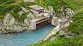
- Main wall
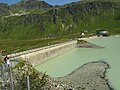
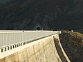
- In the northwest is the main wall with flood relief, bottom drain and circulation tunnel. The gravity dam with a maximum height of 80 m and a crown length of 432 m. It has 407,000 m³ of concrete.
|
Power plant group Obere Ill-Lünersee |
|||||||||||||||||||||||||||||||||||||||||||||||||||||||||||||||||||||||||||||||||||||||||||||||||||||||||||||||||||||||||||||||||||||||||||||||||||||||||||||||||||||||||||||||||||||||
|---|---|---|---|---|---|---|---|---|---|---|---|---|---|---|---|---|---|---|---|---|---|---|---|---|---|---|---|---|---|---|---|---|---|---|---|---|---|---|---|---|---|---|---|---|---|---|---|---|---|---|---|---|---|---|---|---|---|---|---|---|---|---|---|---|---|---|---|---|---|---|---|---|---|---|---|---|---|---|---|---|---|---|---|---|---|---|---|---|---|---|---|---|---|---|---|---|---|---|---|---|---|---|---|---|---|---|---|---|---|---|---|---|---|---|---|---|---|---|---|---|---|---|---|---|---|---|---|---|---|---|---|---|---|---|---|---|---|---|---|---|---|---|---|---|---|---|---|---|---|---|---|---|---|---|---|---|---|---|---|---|---|---|---|---|---|---|---|---|---|---|---|---|---|---|---|---|---|---|---|---|---|---|---|
|
|||||||||||||||||||||||||||||||||||||||||||||||||||||||||||||||||||||||||||||||||||||||||||||||||||||||||||||||||||||||||||||||||||||||||||||||||||||||||||||||||||||||||||||||||||||||
- Side wall
- Also in the northwest, south of the main wall, is the smaller side wall with an additional flood relief. The gravity dam has a maximum height of 31 m, a crown length of 140 m and 18,400 m³ of concrete.
- Bielerdamm
- In the northeast, on a mighty ground moraine of the Vermunt glacier, lies the 25 m high Bielerdamm, an earth dam with a volume of 342,000 m³. The greatest width at the foot is 121 m, the crown length 733 m. The seal is made by a concrete core with a volume of 18,400 m³. On the water side, the dam is protected by 33,000 m³ stone throw.
tourism
summer
In the summer half of the year, the Silvretta reservoir can be reached via the Silvretta High Alpine Road, which is subject to a toll . There are also bus connections from the direction of Paznauntal (June to September) and from the direction of Montafon (June to October) to the reservoir. From about mid-June to mid-October, the “Silvrettasee” large restaurant , located at the north end of the main dam and operated by Golm Silvretta Lünersee Tourismus GmbH , is open during the day.
The mountain inn “Piz Buin” and the hotel “Silvrettahaus” are also directly above the pass.
- A well-paved hiking trail leads around the lake, which leads over the dam, the Bielerdamm and over the large tributaries. A lap around the lake takes a little over two hours. Alternatively, a marked bypass is available for further ascent into the mountains or for a hike around the lake. It leads from the Silvretta house or Restaurant Silvretta through the Silvretta village past the Madlenerhaus to the side wall. This hiking trail bridges the height from the foot of the wall (stop “Madlenerhaus”) to the top of the wall with slight inclines and is also suitable for children.
- The Silvretta motorboat operated on the reservoir from the beginning of July to the end of September . A boat tour was possible from the pier below the Silvrettasee restaurant. In the middle of the hiking trail there is a landing stage for the boat, so that half of it could be covered by boat and the other half on foot. The boat was the only one in Europe that was used for commercial navigation at altitudes over 2000 m. The operation of the boat Silvretta was stopped in 2011 due to an engine failure.
- Fishing in the lake is possible with a license to be purchased. The permit can (also) be purchased at the toll booths.
- Since summer 2019, the max. Various via ferratas were installed about 55 m high air side of the main dam.
Construction-related impairments occurred in the summer of 2010 and in the summer of 2011, as well as since 2014, when the construction of the Obervermuntwerk II began. Dismantling and recultivation measures are to continue until 2020.
winter
In winter, the Silvretta reservoir and the Bielerhöhe ski and touring area can be reached from Partenen via the Vermuntbahn , a cable car from the mountain station of which you can take minibuses through the Trominier tunnel.
- Current signage and information must be observed on winter hikes. The footbridges over the Klostertal Bach and the young Ill will be dismantled before winter due to the snow pressure and the danger of avalanches. As a result of the high water intake or supply through the new Obervermuntwerk II , the lake, on which cross-country ski trails were previously laid out, and whose surface, which was previously completely frozen over, allowed relatively avalanche-safe access to the Wiesbadener Hütte and the Klostertal in the lower part , is no longer over in the northern part . Therefore there is now a short tunnel south of the dams that crosses the most dangerous steep slopes of the Lobspitzen.
The Madlenerhaus ( 1986 m ), located below the main dam and used for years as construction site accommodation , has been open to the public again since July 1, 2019, after the Obervermuntwerk II went into operation.
photos
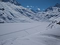
Frozen Silvrettasee with cross-country trails before the Obervermuntwerk II goes into operation
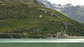
Western dam walls with reservoir keeper's house and Barbara chapel, hotel "Silvrettahaus" (large, white building) and restaurant "Silvrettasee" (in front of Silvrettahaus)

Inflow from Ochsental

Tributary Klostertalbach

Ill confluence

Pressure pipeline to Obervermuntwerk I with Silvrettadorf (front) and Madlenerhaus . Hochmaderer (2823 m) on the right.

Preparation of the rock bottom before starting concreting

The transition from the Bieltal carries plenty of water on a summer's day.
View from Bielerdamm onto the tunnel, drilled in 2017, south of the dams.
The 2017 tunnel crosses the foothills of the Lobspitzen. In the foreground the handles of a climbing route on the main dam.
The setting of the Bieltalbach increases the catchment area of the reservoir by 10 km²

Via ferratas at the main dam and dismantling of the disused penstock to Obervermuntwerk I.


Web links
Individual evidence
- ↑ a b Silvrettasee, illwerkevkw.at
- ↑ Silvretta Hochalpenstraße / Silvretta Bielerhöhe ( Memento from July 6, 2012 in the Internet Archive )
- ↑ Silvretta boat operation
- ^ Illwerke sport fishing association. May 31, 2019, accessed June 7, 2019 .
- ↑ The Madlenerhaus. Retrieved June 7, 2019 .