
Hochmaderer
| Hochmaderer | ||
|---|---|---|
 Hochmaderer from the east ( Bielerhöhe ) |
||
| height | 2823 m above sea level A. | |
| location | Vorarlberg , Austria | |
| Mountains | Silvretta | |
| Dominance | 2.7 km → Gemini | |
| Notch height | 318 m ↓ Hochmadererjoch | |
| Coordinates | 46 ° 55 '52 " N , 10 ° 1' 41" E | |
|
||

The Hochmaderer is a 2823 m high, striking mountain in the Silvretta in the Austrian state of Vorarlberg , at the end of the Montafon . The multi-peaked primary rock plunges in mighty wall lines to the south and east. It is part of an approximately 8 km long ridge that branches off to the north from the main ridge of the Silvretta at the southern tip of the plateau and descends with the last summit, the Breitfielerberg, to Partenen and to the toll station of the Silvretta high alpine road .
The ascent takes place from the Vermuntsee ( 1743 m , bus stop) in 2½ hours from the north, or from the Tübinger Hütte ( 2190 m ) in 1¾ hours through the Gantschettatäli ( 2300 m ) south of the mountain, first to or just before the Hochmadererjoch ( 2505 m ). From here it takes another hour to climb the very steep Gunserweg , which requires sure-footedness, to the summit.
View from the Strittkopf to the south to the Hochmaderer
Hochmaderer from the northwest with the Gunserweg, which leads up from the south over the saddle (right)
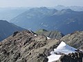
View from Hochmaderer into the Montafon. In the middle distance the green and grazed sheep floor , on the horizon half right the red wall .
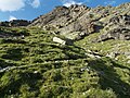
The very steep Gunserweg
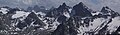
View from Hochmaderer into the Silvretta: Panorama from the Rotfluh to the Kleiner Seehorn

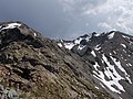
View over the Gantschettatäli and Hochmadererjoch to the Hochmaderer (left), view from the west.
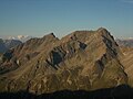
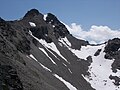
Hochmaderer (right) and Strittkopf (2745 m, left of center) from the Erich-Endriss-Weg. On the far right the Hochmadererjoch.


Individual evidence
- ↑ a b Alpine Club Card No. 26 Silvrettagruppe, 9th edition 2013, ISBN 978-3-928777-37-7