
Silvretta High Alpine Road
The Silvretta High Alpine Road leads from the Vorarlberg Montafon over the Vermunt and the Bielerhöhe through the Silvretta mountains to the Tyrolean Paznaun , the Trisanna valley . The 22.3 km long road between Partenen and Galtür is one of the most popular mountain roads in the Austrian Alps with 400,000 users . The toll road is the work and property of illwerke vkw and is managed by its subsidiary Golm Silvretta Lünersee Tourismus .
Route description
The Silvretta-Hochalpenstraße is part of the Silvrettastraße (B 188), only open in summer and tolls for motor vehicles (2020: € 16.50 for cars up to nine people).
The western approach with 32 hairpin bends begins at the end of Partenen and is around 15 kilometers long to Bielerhöhe or the Silvretta reservoir. The maximum gradient is 12 percent.
The part of the Silvretta High Alpine Road to the east of the lake is in Tyrol, begins in the Galtür district of Wirl at the tollbooth at 1,725 m above sea level in Paznaun, has only two bends and is around ten kilometers long to the same destination.
There are several restaurants on the Bielerhöhe. The Silvretta reservoir is located at the highest point of the road (2,032 meters above sea level) . You can go around the lake on a well-developed hiking trail.
The Silvretta High Alpine Road is an often chosen venue for motorsport events, including vintage car rallies or bicycle races.

history
The Silvretta-Hochalpenstraße was built during the reservoir and power plant construction activities by the Vorarlberger Illwerke . As early as 1925, after the decision to build the Vermunt works, they widened an old unpaved cart path from Partenen up to the Vermuntsee as a transport route so that cement and gravel trucks could bring their freight to the construction site of the Vermunt dam. Not much happened after it was completed in 1930.
It was not until 1938, accelerated by the connection between Austria and Germany, that the line was extended to the Bielerhöhe in order to build the Silvretta dam there. In the further course of the construction work, more prisoners of war and slave labor were used , often under inhumane conditions. With this expansion phase, the historically significant transition at the Zeinisjoch finally lost its importance. The villages of Partenen and Galtür now moved further apart via the detour of Silvrettastraße.
The final completion of the connection between Partenen and Galtür and thus the High Alpine Road was, so to speak, a product of chance: all the construction companies asked did not dare to build the winding road from Vermuntsee through difficult terrain to Partenen. In addition, those responsible found themselves confronted with the problem that there was still an oversized excavator on the Bielerhöhe from the time the dam was built. Instead of dismantling it for transport back to the valley and taking it to Partenen by cable car, as it had been carried up years before, the excavator made its way through the steeply sloping valley to Partenen on its own between 1951 and 1954, with which the basis for today's route was created.
This created a continuous road, which was opened to public traffic in 1954 and expanded to two lanes over its entire length by 1961.


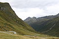

View from the Versalspitze to the Silvretta High Alpine Road and to the Vermuntsee

Escaped grazing animals on the Silvretta High Alpine Road in the Großvermunt area.


Summer and winter operation
In summer there are also bus connections from Landeck and Bludenz via the Silvretta-Hochalpenstraße (or Silvrettastraße) to the Bielerhöhe.
Due to the busy grazing on the road, animals on the road and damage to vehicles can be expected.
The winter closure usually lasts from November to May. If it starts to snow very late, the road can be open until just before Christmas. After the snowy winter of 2018/19, however, it was only opened on June 20, 2019. In winter, however, the shuttle bus service for the Bielerhöhe ski area takes place in the upper part of the route , and visitors can access it via the Vermuntbahn from Partenen.

See also
Web links
Individual evidence
- ↑ a b Description of the route at www.silvretta-bielerhoehe.at
- ^ Silvretta-Hochalpenstraße: vehicle tariffs (Golm Silvretta Lünersee Tourismus GmbH). Accessed February 16, 2020 .
- ↑ Opening times Silvretta-Bielerhöhe in the Montafon. Retrieved June 20, 2019 .
Coordinates: 46 ° 55 ' N , 10 ° 6' E