Cap
| Versalspitze (Versailspitze) | ||
|---|---|---|
|
View from the Wiegensee |
||
| height | 2462 m above sea level A. | |
| location | Gaschurn , Montafon , Vorarlberg | |
| Mountains | Valschavielkamm , Verwall | |
| Dominance | 0.9 km → Tavamunter Augstenberg | |
| Notch height | 57 m ↓ Jöchli (to Tavamunter Augstenberg) | |
| Coordinates | 46 ° 58 '55 " N , 10 ° 5' 6" E | |
|
|
||
| rock | Silvretta crystalline | |
| Normal way | Partenen - Tafamunt; Partenen - Verbellaalpe; Zeinisjoch - Verbellaalpe | |
| particularities | European protected areas Verwall , Wiegensee and debris fields Tafamunt | |
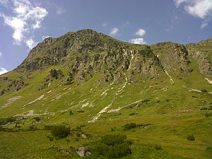
The Versalspitze , also Versailspitze , locally Versal (pronounced [ fer'za: l… ]), is a 2462 m above sea level. A. high mountain in Verwall in the municipality of Gaschurn im Montafon , Vorarlberg .
Location and landscape
The Versalspitze rises above the Gaschurn district of Partenen and the Verbella valley . Together with the neighboring, more dominant Augstenberg ( 2489 m above sea level ), it forms the western end of the Valschavielkamm . The two nearby peaks are connected by the Jöchli ( 2405 m above sea level ). Towards the south, the Versal breaks off in a nearly 500 meter high wall to the Wiegensee ( 1920 m above sea level ). It lies on an intermediate plateau , the cradle , then the Schrofen break off another 500 meters towards the lower Verbella valley ( Alpe Ganifer ), and the Tafamunt over 1000 meters towards Partenen ( 1051 m above sea level ) and the Ill valley.
natural reserve
The Versalspitze forms the southern end of the Verwall bird sanctuary (Natura 2000 AT3412000 , 12,057 ha). On the southern slopes the wild fauna and flora habitat areas are Wiegensee ( AT3413000 ) with 65 hectares and debris corridors Tafamunt ( AT3422000 ) 68 ha. The former captures the lake and its surrounding wetlands and other habitats that Zother scree and steep forests against Illtal. The entire area between the lower Valschavieltal and the Verbellatal (including Augstenberg) is listed in the Vorarlberg biotope inventory as the Tafamunt-Wiege-Versal ( no. 11018 ) large-scale biotope with 1091.7 hectares. Due to the special nature of the area in terms of both species and biotope diversity, it was registered as a jewel of the Gaschurn community .
ways
The mountain can be reached from Partenen ( Kopswerk ) via Tafamunt, a long ascent, or the Tafamuntbahn mountain station, and then the Vendulabach valley. There is the abandoned Versailhaus (Versal-Haus) . Then the path leads easily over the Jöchli to the summit.
The second ascent is from the west, from Alpe Verbella , which can be reached from Partenen via the Verbella valley or - also from the Tyrolean side - from the Zeinisjoch ( Zeinisjochhaus , Kopssee ) , and from there also to the Jöchli.
There is no direct route from Wiegensee to Versalspitze, you have to go around the south face via Tafamuntalpe or Verbellenalpe.
literature
- Hilda Heine, Jörg Heine: Montafon . 2nd Edition. Rother Bergverlag, Munich 1983, ISBN 978-3-7633-3244-1 , Versalspitze , p. 118 ( rother.de ; limited preview in the Google book search).
- Roland Luzian, Peter Pindur, Andreas Weiskopf: Verwall group . 10th edition. Rother Bergverlag, Munich 2005, ISBN 978-3-7633-1251-1 , Versalspitze , p. 148 ( rother.de ; limited preview in the Google book search).
- Markus Staudinger, AVL Arge Vegetation Ecology and Landscape Planning: Gaschurn . Community report. In: Georg Grabherr; Vorarlberg Landscape Conservation Fund; Vorarlberger Landesregierung - Department of Environmental Protection IVe (Ed.): Biotopinventar Vorarlberg . Vorarlberger Verlagsanstalt, Bregenz June 2008, Großraumbiotop Tafamunt-Wiege-Versal (Biotop 11018) , p. 15th ff . ( pdf , vorarlberg.at; online , VOGIS - 1st recording of part of the Montafon inventory. 1984.).
Web links
- Josef Merz: Tafamunt - Versalspitze / Hiking Tour (medium). Tour dates (gps). In: alpintouren.com. June 1, 2003, accessed June 18, 2011 .
- Silvia Spörk: Partenen - Versalspitze - Verbella-A. - Wiegensee. (private homepage) Tour report with photo gallery. Retrieved June 18, 2011 .
Individual evidence
- ↑ The Silvretta Kristallin. In: loccata digital hiking guide galileo.telesis.at → Geological trail. Montafon Tourismus, accessed on June 17, 2011 .
- ↑ a b f & b hiking map sheet 37 Rhätikon-Silvrettagruppe 1: 100000, approx. 1960s
- ↑ Verbellatal is said to be derived from Val bella (beautiful valley) and is one of around 415 Rhaeto-Romanic field names in Gaschurn-Partenen. The name suggests a development by the Rhaeto-Romans , whereby a linguistic shift took place, since "Val" already means "valley". See [1] .
- ↑ Tafamuntbahn


