Valschavielkamm
| Valschavielkamm | |
|---|---|
|
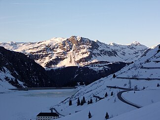
Valschavielkamm with Schassnergrat (left, snow-covered), Versalspitze (middle, dark) and the Strittkopf (right behind, snow-covered). In the foreground Vermuntsee and Obervermuntwerk I. |
|
| Highest peak | Eastern Valschavielberg ( 2623 m above sea level ) |
| location | Vorarlberg |
| part of | Verwall |
| Coordinates | 47 ° 1 ' N , 10 ° 8' E |
| Age of the rock | Precambrian |
The Valschavielkamm is part of the south-eastern Westverwall ( western Verwall group ) and is located in Vorarlberg and in a Natura 2000 area ( AT3412000 ).
The southwestern part of the Valschavielkamm with the Schassnergrat and the Versalspitze (also: Versailspitze, 2462 m above sea level ) rising from the west to Tavamunter Augstenberg ( 2489 m above sea level ) delimits the Valschavieltal in the south. Approximately in the middle of the ridge is the western Valschavielberg ( 2546 m above sea level ), between the Verbellakopf ( 2581 m above sea level ). The south-western part is easily accessible via the Tafamuntbahn and the Maiensäß Tafamunt as well as the Heilbronner Hütte . The northeastern end of the Valschavielkamm with the main summit, the Eastern Valschavielberg ( 2623 m above sea level ) and the Stritkopf ( 2604 m above sea level , near the border with Tyrol ), is less accessible.
The steep drop of the Valschavielkamm above the Rotte Rifa between Gaschurn and Partenen is known as Tafamunt (also Tavamunt and similar).
The south of the Schassnergrates standing, built in 1931 and since 1967 no longer farmed Versailhaus originally served as a base for hiking in the area of Valschavielkamms.
Name derivation
In the land registry of the Sonnenberg domain from 1423, the Alpe was written as "Valtschevill". In a judgment of the March Court in Gaschurn, spoken by Adam Salomon, subordinate and judge of the city and rule of Bludenz on August 6, 1654, the name of the valley was given as "Faltschefiel".
AR Schmidt and Johann Nepomuk Friese in " Vorarlberg described geognostically after the inspections initiated by the geognostic-mining association for Tyrol and Vorarlberg and shown on a geognostic map ", Innsbruck 1843, mention "Valschaviel" in today's spelling. Josef Trentinaglia-Telvenbur also mentions the Valschavielkamm in this spelling in " The area of Rosanna und Trisanna " from 1875. The name of the Valschavielkopf, -bach and -alpe is said to have been written after Josef Zösmaier in 1783 as "Valschviel", in 1610 Vallschaviel, Vallschwiel and similar. Spoken as Valtschafiel in 1923. Zösmair derives the word from vallis cavalli with the meaning "Roßtal" or "Gaultal". As a further interpretation he mentions “vallis clavis” in the sense of “key valley”, in connection with the transition over the Winterjöchl to Tyrol as such a key access.
hike
The Valschavielkamm can be reached on foot from the valley ( Gaschurn / Partenen ) in around four to five hours (more convenient with the Tafamuntbahn from Partenen). All the peaks of the Valschavielkamm are relatively close to one another and can be reached in half an hour (e.g. Versalspitze to Augstenberg) to one and a half hours (e.g. from eastern to western Valschavielberg). The entire Valschavielkamm can be walked lengthways in about six to seven hours. Medium level of fitness is required.
literature
- Peter Pindur, Roland Luzian, Andreas Weiskopf: Alpine club guide "Verwallgruppe", Bergverlag Rother, 10th edition, 2005, ISBN 3-7633-1251-X .
- Alpine Club Maps : Sheet 28 Verwallgruppe , 1: 50,000, 2010. Sheet 28/2 Verwallgruppe-Mittelesblatt , 1: 25,000, 2009.
- Compass: WK 41 Silvretta-Verwall Group , 1: 50,000, 2009.
- freytag & berndt: WK 372 Arlberg area, Paznaun, Verwall group , 1: 50,000.
Web links
- Verwall-Runde - detailed information about hiking in the Verwall with tour suggestions on Verwall.de
Individual evidence
- ↑ The 2696 m above sea level. A. high Valschavielkopf , the Valschavieler Plattenspitze ( 2561 m above sea level ) and the Valschavieler Albonakopf ( 2482 m above sea level ) belong to the Madererkamm .
- ↑ Heimatbuch Gaschurn-Partenen, published by the community of Gaschurn, Gaschurn 1985, p. 112
- ↑ Heimatbuch Gaschurn-Partenen, published by the community of Gaschurn, Gaschurn 1985, p. 122
- ^ Google Books .
- ^ Google Books .
- ↑ Josef Zösmair, Die Bergnames Vorarlbergs, UT: if possible explained on a documentary basis, Verlag der Vorarlberger Buchdruckerei-Gesellschaft mbH, Dornbirn 1923, p. 24.
