
Rote Wand (Lechquellen Mountains)
| Red wall | ||
|---|---|---|
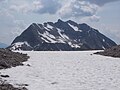
 Red wall with the typical, eponymous red color and the Jungferngipfel as the apparently highest point |
||
| height | 2704 m above sea level A. | |
| location | Vorarlberg , Austria | |
| Mountains | Lechquellen Mountains | |
| Dominance | 10.9 km → Untere Wildgrubenspitze | |
| Notch height | 900 m ↓ Spullersee -Sattel | |
| Coordinates | 47 ° 11 '10 " N , 9 ° 59' 6" E | |
|
||
| rock | Lech Formation , Ammergau Formation , Ruhpolding Formation , Allgäu Formation , Oberrhätkalk , Kössen Formation , main dolomite | |
| Age of the rock | Upper Carnian - Turonian | |
| First ascent | September 12, 1867 by John Sholto Douglass and Baron Otto von Sternbach (tourist) | |

The Rote Wand is the most striking and with a height of 2704 m above sea level. A. after the Unteren Wildgrubenspitze ( 2753 m above sea level ) the second highest mountain in the Lechquellen Mountains . It rises between Buchboden ( Großes Walsertal ) in the north and Dalaas ( Klostertal ) in the south. The name Rote Wand comes from the red Lias limestone , which is particularly noticeable in the up to 400 m high south wall. On the north side, below the summit, there is a small glacier, which is one of the most impressive and lowest (about 2600 m) glaciers in the Northern Alps. On the south side there is the Formarinsee ( 1789 m ) at the foot of the Rote Wand and the Freiburger Hütte ( 1931 m ) above its south bank .
In the literature (e.g. in the area guide "Bregenzerwaldgebirge and Lechquellengebirge" by Dieter Seibert) there are allegations that the first ascent had already been carried out on July 25, 1610 by the Bludenz bailiff captain David Pappus (incorrectly called "David Kappus" by Seibert) and Companions took place, may be doubted. Manfred Tschaikner came to the conclusion that climbing high peaks, such as the Schesaplana or the Rote Wand, was not necessary and did not take place in order to complete Pappus' assignment, the border inspection.
In the Atlas Tyrolensis of 1774 the Rote Wand is called Horn Spitz . The conspicuous Felshorn southwest of the main summit is the Jungferngipfel ( 2686 m ).
Its wooden summit cross from 1966 was dismantled in summer 2020 and replaced by a new one, which was carried up by mountaineers.
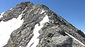
The mountain is a popular hiking destination (only for experienced mountaineers who do not suffer from vertigo). The hiking routes can be started from the Alpe Laguz (here hiking bus in summer), the Alpe Klesenza, the Formarinalpe and the Freiburger Hütte. They all flow into the very steep north-west flank and lead over snow fields that lie well into summer and finally exposed in easy climbing ( UIAA I +) over the north-west ridge to the summit (walking time from the shelter approx. 3 1 ⁄ 2 to 4 hours) .
view
The mountain, which clearly towers above its surroundings, allows a wide view, especially to the south, west and north. One looks (from east to south to west) of the Allgäu and Lechtal Alps, the Verwall, the Silvretta, the Rätikon, the Glarus Alps and the Alpstein. In the wider area you can see: Zugspitze , Karwendel ( Birkkarspitze ), Ötztal Alps ( Wildspitze , Weißkugel ), part of the Ortler Alps ( Zufallspitze , Monte Cevedale ), almost the entire Bernina group from Piz Cambrena to Piz Rosegg , Piz Julier , Piz Platta , Pizzo Tambo , Rheinwaldhorn , Tödi , parts of the Bernese Alps more than 150 km away ( Fiescherhörner , Wetterhorn , Rosenhorn), Groß Schärhorn , Groß Spannort , Titlis , Glärnisch and Pilatus . If the air is clear enough, the view extends to the Feldberg in the Black Forest , 168 km away , and even as far as the Vosges ( Le Ballon , 1052 m , 253 km). The Ulm Minster Tower, 135 km away , can also be made out precisely in the north, provided the air is clear.
Trivia
As part of the ORF broadcast 9 Places - 9 Treasures , the Formarinsee with the Rote Wand 2015 was voted the most beautiful place in Austria.

Red wall at sunrise

Red wall from the south

View from Fürkele, 2310 m (also called "Oberes Sättele"), into the northwest flank

Glacier and north ridge shoulder, left the Jungferngipfel

Rote Wand from the northwest, below the Lower Laguzalpe
Red wall from the Johannesjöcher area

The overhanging maiden peak from west-southwest

In the northwest flank you can see these Lia limestone rock debris, which gives the mountain its name.
The last 50 meters to the summit. The wooden cross has just been dismantled.


Web links
Individual evidence
- ^ Federal Office for Metrology and Surveying Austria: Austrian Map online (Austrian map 1: 50,000) .
- ↑ Surface map 1:50 000 for the area guide “Bregenzerwaldgebirge and Lechquellengebirge”, 1st edition 1989 by Dieter Seibert
- ↑ a b c d Dieter Seibert: Area guide "Bregenzerwaldgebirge and Lechquellengebirge" . 1st edition. Bergverlag Rudolf Rother, Munich 1989, ISBN 3-7633-3328-2 , p. 166 .
- ↑ Manfred Tschaikner: The land register of the dominions Bludenz and Sonnenberg from 1620 - an overview . In: Bludenzer Geschichtsblätter (Ed.): History Association Region Bludenz . tape 104 . Self-published, Bludenz 2013, ISBN 978-3-901833-32-8 , p. 55 .
- ↑ vorarlberg ORF at red: Summit cross carried at 2,704 meters. July 4, 2020, accessed July 8, 2020 .
- ↑ PeakFinder Ltd [email protected]: Mountain panorama: Rote Wand. Retrieved May 29, 2020 .
- ↑ orf.at - Formarinsee is the "most beautiful place" . Article dated October 24, 2015, accessed October 24, 2015.