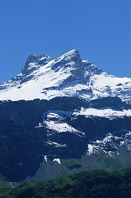
Gross Schärhorn
| Gross Schärhorn | ||
|---|---|---|
|
View from the Klausenpassstrasse |
||
| height | 3294 m above sea level M. | |
| location | Canton of Uri , Switzerland | |
| Mountains | Alps ( Glarus Alps ) | |
| Dominance | 6.35 km → Piz Russein | |
| Notch height | 513 m ↓ sand pass | |
| Coordinates | 706101 / 187 151 | |
|
|
||
| First ascent | 1842 by G. Hoffmann with J. Gisler with PL Imholz | |
| Normal way | South-east flank from the Hüfihütte | |
The Gross Schärhorn ( 3294 m above sea level ) and the Chli Schärhorn ( 3234 m above sea level ) about 400 meters to the west form a characteristic double peak in the canton of Uri in Switzerland . It rises between the rear Maderanertal and the rear Schächental and is located in a mountain range north-west of the Tödi . To the northeast of the Schärhorn follow the Chammliberg , the Clariden , the Bocktschingel and the Gemsfairenstock . To the south-west, the Chli- and Gross Ruchen and the Goss- and Chli Windgallen belong to the same mountain range.
As a day tour, the easiest route leads from the Klausenpass to the Chammlialp, then over the moraines of the Griesfirn in a steep ascent to the always glaciated Chammlilücke ( 2854 m ) and from there to the east ridge of the summit. The east ridge can also be reached from the Hüfihütte in the south or from the Planurahütte in the east via the Hüfifirn .
Web link
literature
- Richard Goedeke : 3000er in the Northern Alps , Bruckmann, Munich 2004, ISBN 3-7654-3930-4

