
Gemsfairenstock
| Gemsfairenstock | ||
|---|---|---|
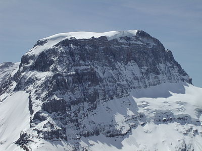
 Gemsfairenstock, taken from the Claridenhütte |
||
| height | 2972 m above sea level M. | |
| location | Border canton Glarus / canton Uri , Switzerland | |
| Mountains | Alps ( Glarus Alps ) | |
| Dominance | 1.64 km → Gross Tüfelsstock | |
| Notch height | 124 m ↓ Gemsfairenjoch | |
| Coordinates | 712.79 thousand / 190 989 | |
|
||
| First ascent | August 15, 1854 by Studer and Fahrtisen | |
| Normal way | North flank over the Langfirn ( T4 alpine hiking ) | |
| particularities | Popular ski touring summit | |

The Gemsfairenstock (also only Gemsfairen ) is 2972.1 m above sea level. M. high mountain in the Glarus Alps . From its summit you have a good view of the northwest face of Tödis to the south .
location

The border between the Swiss cantons of Glarus and Uri runs over the summit of the Gemsfairenstock .
The Gemsfairenstock forms the eastern end of the Gross Schärhorn - Clariden - Bocktschingel - Gemsfairenstock chain (from west to east). To the south the mountain falls with steep cliffs on the Claridenfirn , which to the west over the 2952 m above sea level. M. high Claridenpass (also Hüfipass ) to the Hüfigletscher . The less steep north flank is covered with the Lang Firn . To the north is the Urner Boden .
Routes
The mountain is a popular destination , especially among ski mountaineers . The normal route leads from the Fiseten Pass ( 2036 m above sea level ), which is reached by a small cable car from Urnerboden, over the round hole ( 2287 m above sea level ) and the Lang Firn to the summit. In summer the route is an alpine hike with difficulty T4 according to the SAC hiking scale . The same route is very often used as a ski tour in winter. The exposed summit flank is often very faded.
Another ascent option is from the south via the Claridenhütte .
panorama

gallery

View to the Claridenfirn.
Look at the Tödi.

Aerial view of the Gemsfairenstock in 1925.

Gemsfairenstock in the foreground, Tödi in the background.

