Urnerboden
| Urnerboden, Urnerboden | |
|---|---|
| State : |
|
| Canton : |
|
| District : | No district division |
| Residential municipality : | Spiringen |
| Postal code : | 8751 |
| former BFS no. : | 1218 |
| Coordinates : | 711 382 / 193 504 |
| Height : | 1372 m above sea level M. |
| Area : | 42.15 km² |
| Residents: | 25 (2017) |
| Population density : | 1 inhabitant per km² |
| Website: | www.urnerboden.ch |
|
The Uri soil in June |
|
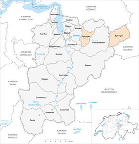
| map | |
The high valley, the Urner Boden , is the largest alp in Switzerland and the Kirchenweiler Urnerboden (also called "Boden" or "Ennetmärcht") is a small settlement inhabited all year round.
Location and affiliation
The Urner Boden is an 8 kilometer long high valley wedged in by almost 3000 meter high mountains east of the Klausen Pass . It belongs to the canton of Uri , even though it is geographically across the watershed on the Glarus side. Politically, it is an exclave of the municipality of Spiringen .
Transport links
The Urner Boden can only be reached via Hauptstrasse 17 in the summer months from Uri via the Klausenpassstrasse, which was opened in 1900. The Klausenpass ( 1948 m above sea level ) is not passable in winter . Then Urnerboden can only be reached from Linthal in the canton of Glarus , unless avalanches have made this route impassable.
history
In 1315 the border between Glarus and Uri was precisely marked out. Years of disputes came to an end, and the Ennetmärch (ennet = Swiss. For beyond, March = Swiss. For field boundary) belonged to the people of Uri. Staying on the Uri soil during the winter was forbidden by law until 1877. Today around 25 residents stay on the alp during the winter. In 1899 the small village got its own school, in 1902 it became a permanent chaplain, which from 1913 was allowed to bury its dead in its own cemetery. In 1915 Urnerboden finally got its own church. In 1935 250 people lived on the Uri soil, in 2003 there were still around 40. School and post office were closed.
In his poem "The Border Run", the poet Otto Ernst tells a (hypothetical) story of the dispute between Uri and Glarus over the Uri soil. The same story also exists as a legend.
economy
The inhabitants of Urnerboden live mainly from alpine farming and agriculture. Up to 1200 cows and 700 cattle are summered in the high valley. During this time, the small cheese factories there for the production of alpine cheese are put into operation. Tourism has also been an important source of income since the opening of the pass road; in summer the alp is very popular.
Excursions, sports and culture
Urnerboden is a starting point for mountain climbing, climbing and ski tours. In winter, the Uri soil is used for cross-country skiing. In winter it is an ice climbing destination. The « Urnerbodenschwinget » takes place every second summer and the « Verenenchilbi » every autumn . In addition, the Urner Boden also offers a flight area for paragliding fans.
Since 2002 a small cable car for six people has led from Urnerboden to 2036 m above sea level. M. high Fisetenpass . This is the starting point for numerous hikes and mountain tours, e.g. B. on the Gemsfairenstock , the Clariden , to the Klausenpass or to the Claridenhütte .
The region gained greater national fame in 2017 as the location for the Swiss crime series Wilder by SRF .
Attractions
Web links
- Urnerboden website
- Hans Stadler: Urnerboden. In: Historical Lexicon of Switzerland .
- Mythically removed from the world
Individual evidence
- ↑ de.wikisource.org: Der Grenzlauf - Wikisource , accessed on May 21, 2010
- ↑ ub.uni-bielefeld.de: Bielefeld University Library: Otto Ernst: Siebizig Gedichte (digital reconstruction) , accessed on May 21, 2010
- ↑ Legend of the Urnerboden


