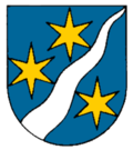
Linthal GL
| GL is the abbreviation for the Canton of Glarus in Switzerland and is used to avoid confusion with other entries of the name Linthal . |
| Linthal | ||
|---|---|---|
| State : |
|
|
| Canton : |
|
|
| District : | No district division | |
| Political community : | Glarus South | |
| Postal code : | 8783 | |
| former BFS no. : | 1613 | |
| Coordinates : | 718 734 / 197 568 | |
| Height : | 662 m above sea level M. | |
| Area : | 131.24 km² | |
| Residents: | 1088 (December 31, 2010) | |
| Population density : | 8 inhabitants per km² | |
| map | ||
|
|
||
Linthal is a former political municipality in the canton of Glarus in Switzerland .
The village was under the Glarner municipal reform on 1 January 2011, with the municipalities Betschwanden , Braunwald , Elm , Engi , Haslen , Luchsingen , Matt , Mitlödi , Rüti (GL) , Schwanden (GL) , Schwändi and Sool merged to Glarus South merged.
geography

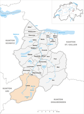
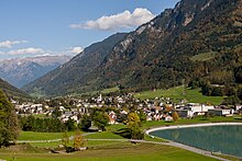
The village of Linthal is located in the upper Linth valley, north of the Linth headwaters . Southwest of the village flows from left of Fätschbach and north of it from the right Durnagel in the Linth, the north towards Linthebene flows away. Until 2010 Linthal was the southernmost municipality in the canton. With a good 131 km², Linthal had the largest municipal area of all Glarus municipalities. The municipal area included the Limmerensee ( 1857 m above sea level ) and the Muttsee ( 2448 m above sea level ), two reservoirs owned by the Linth-Limmern AG (KLL) power plants .
The highest peaks of the Glarus Alps are located in the southern part of the formerly independent municipality . The highest point of the municipality and also of the canton is 3614 m above sea level. M. high Tödi ( advises Piz Russein ), on the border with the canton of Graubünden .
history
The name Lintal is mentioned in ancient writings in 1289 and could be derived from the Gallic lintä (the mighty, flexible), which would indicate the river of the same name. A chapel is documented as early as 1283 , which was named a parish church from around 1319 . In 1333 a nurses' hermitage was mentioned next to the church. In Habsburgs and Säckinger Urbar Linthal was still as Tagwen out low and Oberlin valley. In 1395 the final ransom of the basic interest of the Säckingen monastery could be dealt with
In 1457 the first stone arch bridge, named Pantenbrücke , was built over the deep, narrow Linth Gorge south of Tierfehd . This opened up access to Baumgartenalp, which enabled cattle to graze in the Alps. Until the 18th century people lived in the valley from agriculture and forestry, the breeding of slaughter cattle for export and service. The demand for dairy products rose sharply in the 18th century. This led to the fact that the numbers of slaughter cattle decreased in favor of the dairy cows
Additional income opportunities opened up in 1714 through homework in the cotton spinning mill and in 1760 through hand weaving. Until 1897 Linthal was still called Linththal . In 1838 Heinrich Kunz opened the Kunz spinning mill in Linththal . Kunz employed around 300 people. In 1852 the Becker brothers from Ennenda founded a fine spinning and weaving mill. The spinning mill, known as the Bebié wool factory since 1901, was known for the production of knitting yarns until 1998
economy
Linth-Limmeren power plants
Besides tourism, one of the most important branches of the economy in Linthal is the production of electrical energy through hydropower. For this purpose, Kraftwerke Linth-Limmern AG (KLL) was founded on June 25, 1957 and entered in the Glarus commercial register. The power plant went into operation between 1964 and 1968. The water from the source area of the Linth was optimally used by three power plants. In two expansion steps, the power plant output of the existing systems was increased from the original 340 MW to 1445 MW
traffic
Street
Linthal is the starting point of the Klausenpassstrasse . Centuries ago there was a mule track over the Klausenpass into the Urner Reuss Valley . Associated with this is the legend of the demarcation of the border on the Klausen Pass between Glarus and Uri, which says that the border disputes were resolved with a race. One runner should start from both sides and the future boundary should be where they meet. The people of Uri preferred the start time for the first crowing of the cock in the morning by starving their roosters and they started to scream in the middle of the night. So the Urner runner passed the top of the pass and continued running towards Glarus until he met the Glarner runner. Whether true or not, from Linthal in a south-easterly direction, after a short steep stretch where today's road runs in serpentines, you reach a wide high valley, the Urner Boden . After only 5 km as the crow flies, you reach 1310 m above sea level. M. the border to the Canton of Uri, from where it is another 8 km as the crow flies to the Klausen Pass (1948 m above sea level).
The relatively well-developed Klausenpassstrasse is part of Hauptstrasse 17 (Leibstadt – Zurich – Rapperswil – Glarus – Altdorf) and a popular excursion route for motorcyclists in summer. Since the Klausenpass is not safe for winter, the Urner Boden can only be reached from Glarus during the winter months.
From Linthal a road leads south through the Linth valley to the scattered settlement Tierfehd (805 m above sea level) at the foot of the Tödi. The main purpose of the road is to develop the power stations of the same name and the cavern power station (816 m above sea level) below the Limmerensee
railroad
On June 1, 1879, Linthal was connected to the Swiss railway network, which was under construction, with the opening of the last section of the Weesen-Linthal line. Little has changed on the line that was opened by the Swiss Northeastern Railway (NOB) to this day. The 15.85 km long, single-lane route leads from the canton capital, Glarus, over an altitude difference of 175 meters to the end of the route in the district of (Unter-) Ennetlinth (648 m above sea level), with a single possibility of crossing for trains in Schwanden.
To mark the 125th anniversary of the line in 2004, the modernization of the 10.6 km long Schwanden – Linthal section began. Public facilities such as platform heights and lengths have been adapted to the current SBB standards. In addition to optimizing the infrastructure by expanding switches and stump tracks, and removing unguarded, accident-prone level crossings, the focus was on the implementation of remote control from the Ziegelbrücke signal box.
Linthal has been the location of the valley station of the meter-gauge Braunwaldbahn , an almost 1.4 km long funicular to the car-free resort of Braunwald GL (1256 m above sea level) in the north, since 1907 .
Attractions
The community is known as a starting point for hikes in the Glarus Alps , as well as for excursions to Braunwald and the Klausen Pass .
The Via Alpina long-distance hiking trail runs with stage C4 from Elm in the Sernftal to Linthal over the 2261 m high Richetli pass . From Linthal via Tierfehd, the Muttenalp and the 2714 m high Kistenpass you get to Brigels in the Bündner Vorderrheintal .
Suvorov Museum
The Suworow Museum was founded in 1986 and has been in Linthal since June 2012. Pictures, books and archaeological finds from the time when the Russian generalissimo Alexander Wassiljewitsch Suworow crossed the Alps through Switzerland with the Russian army in the course of the second coalition war are shown
Personalities
- Bernhard Becker (1819–1879), Protestant clergyman and social politician
- Jacques Schiesser (* 1848 in Linthal; † August 18, 1913 in Bern), entrepreneur
- Kurt Albert (* 1952), conductor of the country band Echo vom Tödi
- André Reithebuch (* 1986), Mister Switzerland 2009
Web links
- Karin Marti-Weissenbach: Linthal. In: Historical Lexicon of Switzerland .
- Karin Marti-Weissenbach: Ennetlinth. In: Historical Lexicon of Switzerland .
- Official website of the Suworow Museum in Linthal
Individual evidence
- ↑ a b Glarus Süd.ch: Linthal . Retrieved February 15, 2020
- ↑ Historical Lexicon of Switzerland: Glarus (Canton) , 3.2. Economy. Contribution by Anne-Lise Head-König. Retrieved February 15, 2020
- ↑ Historical Lexicon of Switzerland: Linthal . Article by Karin Marti-Weissenbach, October 27, 2016. Accessed February 15, 2020
- ^ Swiss Confederation: Maps of Switzerland , Zeitreise Kartenwerke 1897. Retrieved on February 28, 2020
- ↑ Südostschweiz.ch: Linthal spinning mill becomes Linthal power plant , article from April 17, 2019. Accessed on February 15, 2020
- ^ Spinnerei Linthal AG: History of the Heinrich Kunz spinning mill , Linthal. Retrieved February 15, 2020
- ↑ Axpo: The future of hydropower - Linthal 2015 Linth-Limmern power plants. S. 8. Retrieved February 15, 2020
- ^ Südostschweiz.ch: More storage capacity in Tierfehd , October 23, 2011. Accessed February 15, 2020
- ↑ Museums.ch: Suvorov Museum . Retrieved February 15, 2020
- ↑ schweizer-illustrierte.ch: André Reithebuch , accessed on July 17, 2009


