
Niederurnen
| Niederurnen | ||
|---|---|---|
 |
||
| State : |
|
|
| Canton : |
|
|
| District : | No district division | |
| Political community : | Glarus North | |
| Postal code : | 8867 | |
| former BFS no. : | 1622 | |
| UN / LOCODE : | CH NOW | |
| Coordinates : | 722 551 / 220843 | |
| Height : | 430 m above sea level M. | |
| Area : | 14.1 km² | |
| Residents: | 3928 (December 31, 2010) | |
| Population density : | 279 inhabitants per km² | |
.jpg) Niederurnen |
||
| map | ||
|
||

Niederurnen is a place in the municipality of Glarus Nord in the Swiss canton of Glarus .
coat of arms
The municipal coat of arms is composed of the family coat of arms of the nobles of Uranen and that of Oberwindeck . It is based on the information in the Book of Arms by Aegidius Tschudi from 1532.

geography

The municipality of Niederurnen is located in the Glarus Unterland on the Chli Linthli , the Linth Canal on the left . The part of the village of Ziegelbrücke , which lies south of the Linth, belongs to the municipality . The Niederurnertäli , the only alpine meadows in the municipality, also belongs to the municipality. At 1896 m above sea level M. the Chöpfberg is the highest point in the community. 10.6% of the community area is populated, 37.2% are used for agriculture, 45.9% are forested and 6.4% are unproductive.
Existing and former neighboring communities
The municipality of Niederurnen borders Bilten in the north, Schänis ( Canton St. Gallen ) in the northeast, Weesen (SG) in the east, Mollis in the southeast, Oberurnen in the south and Schübelbach ( SZ ) in the west .
population
Around 1550, 200 people lived in Niederurnen, by 1701 the number rose to 530 and by 1799 it was 770. In 1837 the number of inhabitants had risen to 1,300 people and was around 1,500 in 1850. By 1960 the population had risen to 3,400 The number of inhabitants has increased since then, and development has been slower.
Economy and Transport
The land gain through the Linth correction caused a strong upswing. In 1830 a textile printing shop was established, which was followed by asbestos cement production by Eternit AG in 1903. The Fritz + Caspar Jenny AG spinning and weaving mill has existed since 1834. In the course of industrialization in the 19th century, Niederurnen developed into an industrial village thanks to its favorable location at the end of the Glarus valley.
There is a connection to the A3 Zurich - Chur motorway for private transport . The Ziegelbrücke station of the Swiss Federal Railways is of regional importance. It is also the terminus of the S2 line of the Zürcher Verkehrsverbund . Trains run regionally from Nieder- and Oberurnen station. Niederurnen is served by the Glarus bus on the Mühlehorn – Kerenzerberg – Mollis – Näfels – Oberurnen – Niederurnen – Ziegelbrücke / –Bilten line. The Swiss Federal Railways are the licensee.
history
The first evidence of human presence in the municipality is a Celtic bronze sword that was found while the Linth Canal was being built.
The community name is derived from the Latin villa orana (= country estate on the Bort, edge). The name Niter urns has been used since the 11th century . Niederurnen originally belonged to the Schänis Monastery . Oberwindegg Castle was first mentioned in a document in 1265. In the 13th and 14th centuries, Niederurnen was a bone of contention among various lords, including the Kyburger , Rapperswiler , Habsburgs and the Wettingen , Einsiedeln , Schänis and Säckingen monasteries . In 1386 the castle was destroyed and Niederurnen came under the rule of Glarus.
The first rail link was established in 1875 with the connection to the Nordostbahn network. In 1904 a power station was put into operation, which is fed by the Dorfbach.
Niederurnen was merged with the municipalities of Bilten , Filzbach , Mollis , Mühlehorn , Näfels , Oberurnen and Obstalden to form the new unified municipality of Glarus Nord on January 1, 2011 as part of the Glarus municipal reform .
Attractions
The Niederurner Alpental or Täli , which is accessible by the Niederurnen-Morgenholz cable car, extends over 6.5 km in a west-east direction. From the watershed on Melchterli and Feldrederligrat, the view extends to Lake Zurich and Etzel or to the Black Forest and Jura . The municipal boundary between Niederurnen and Bilten leads along a ridge over the Planggenstock and the Hirzli. These two mountain peaks are also popular viewpoints for hikers.
Culture
House Muehle in Niederurnen was built in the 18th century. In the basement of the house was the mill, which until 2014 was as it was in 1958, when the mill was shut down. In 2003 the artist Armin Simon bought the house and organized exhibitions, readings, concerts, etc. there. In 2014 it was sold and the mill was expanded for renovation.
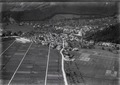
Niederurnen, historical aerial photo from 1925, taken from a height of 300 meters by Walter Mittelholzer
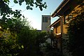
Catholic Church

reformed Church

Parish hall

Schoolhouse and information board
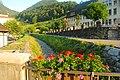
Dorfbach

Dorfbach

school


Web links
- Karin Marti-Weissenbach: Niederurnen. In: Historical Lexicon of Switzerland .
Glarus | Glarus North | Glarus South
Former municipalities: Betschwanden | Bilten | Braunwald | Diesbach | Elm | Engi | Ennenda | Filzbach | Haslen | Hätzingen | Kerenzen-Mühlehorn | Leuggelbach | Linthal | Luchsingen | Matt | Mitlödi | Mollis | Mühlehorn | Näfels | Netstal | Nidfurn | Niederurnen | Head urns | Obstalden | Riedern | Rüti | Schwanden | Schwändi | Sool