Nidfurn
| Nidfurn | ||
|---|---|---|
| State : |
|
|
| Canton : |
|
|
| District : | No district division | |
| Political community : | Haslen GL | |
| Postal code : | 8772 | |
| former BFS no. : | 1621 | |
| Coordinates : | 722 977 / 205314 | |
| Height : | 578 m above sea level M. | |
| Residents: | 258 (July 2007) | |
| map | ||
|
|
||
Nidfurn is a village in the political municipality Haslen in the canton of Glarus in Switzerland . Nidfurn was an independent municipality until July 1, 2006.
In 2011 Haslen (Nidfurn, Leuggelbach, Haslen) was integrated into the greater municipality of Glarus Süd .
coat of arms
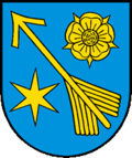
Blazon : Yellow arrow slanted in blue accompanied by a yellow rose above and a six-pointed yellow star below
In the coat of arms the genders are represented by symbols Schmid (arrow), Blumer (rose) and Böniger (star).
geography
Nidfurn is on the Schwanden - Linthal - Urnerboden UR - Klausenpass road. The valley here faces south and widens to a width of one kilometer. 4.7% of the community area is populated, 33.3% are used for agriculture, 47.3% are forested and 14.7% are unproductive.
The nearby mountain Nidfurner Turm is named after the place.
population
| Population development | |
|---|---|
| year | Residents |
| 1960 | 382 |
| 1990 | 279 |
| 2000 | 258 |
| 2005 | 271 |
| 2007 | 258 |
The population decreased between the years 1850 and 1888 from over 600 to just under 400. Between 1960 and 1990 the number of Nidfurner fell steadily from 382 to 279 and leveled off. The current level is 258. However, today's housing subsidies could possibly increasingly bear fruit.
politics
The Social Democratic Party of Switzerland (SP) has 73.9% of the votes, 26.1% of the votes go to other parties (2003).
economy
Nidfurn is accessible to public and private transport via the Glarus –Linthal railway line and the cantonal road. In Nidfurn, no major industry has developed in and of itself, which is why around 60% of the workforce commute to other communities in the canton of Glarus and neighboring cantons. In 2002 Marelcom, which until then had been domiciled in Haslen, built a new production facility for products such as LED liquid crystal displays and membrane and silicone keyboards. And in 1998 Tödiplast built its new production building in Nidfurn.
history
The community was in Habsburg Urbar first of 1302 as ze Nitfúre mentioned. The name is derived from Fur for slope. Nidfurn separated from the Glarus Church in 1350, and the Nidfurners have been part of the church in Schwanden ever since.
In 1879 the community was connected to the Nordostbahn railway network (Nidfurn-Haslen station). In the 1960s the Tödi – Greina project (Ziegelbrücke – Glarus – Trun – Biasca) was launched, but was not carried out. That could have been the chance for better industrialization of practically all valley communities.
On July 1, 2006, the merger of the municipalities of Haslen , Leuggelbach and Nidfurn to form the new municipality of Haslen became legally binding. In 2011, the Landsgemeinde decided to merge all the municipalities of the Canton of Glarus into three large municipalities. As a result, Nidfurn becomes part of Glarus Süd, which includes today's region of Glarus Hinterland and Sernftal with the municipalities of Mitlödi, Schwändi, Sool, Schwanden, Haslen, Luchsingen, Betschwanden, Rüti, Braunwald, Linthal, Engi, Matt, Elm.
Web links
- Karin Marti-Weissenbach: Nidfurn. In: Historical Lexicon of Switzerland .


