
Engi GL
| GL is the abbreviation for the canton of Glarus in Switzerland and is used to avoid confusion with other entries in the name Engi . |
| Engi | ||
|---|---|---|
 |
||
| State : |
|
|
| Canton : |
|
|
| District : | No district division | |
| Political community : | Glarus South | |
| Postal code : | 8765 | |
| former BFS no. : | 1606 | |
| Coordinates : | 730 426 / 204886 | |
| Height : | 812 m above sea level M. | |
| Area : | 40.7 km² | |
| Residents: | 609 (December 31, 2010) | |
| Population density : | 15 inhabitants per km² | |
| map | ||
|
||


Engi is a village that belongs to the municipality of Glarus Süd in the Swiss canton of Glarus .
The formerly independent local community became a new one as part of the Glarus community reform on January 1, 2011 with the local communities Betschwanden , Braunwald , Elm , Haslen , Linthal , Luchsingen , Matt , Mitlödi , Rüti (GL) , Schwanden (GL) , Schwändi and Sool Glarus South municipality merged.


geography
The place is in the Sernftal on the Sernf, the eastern tributary of the Linth , before it flows into the Linth in Schwanden. Engi is the northernmost village in the Sernftal. The settlement area is elongated and consists of the parts Vorderdorf, Dörfli and Hinterdorf . The former municipal area includes steep, wooded mountain slopes, high Alps and up to 2500 m above sea level. M. high mountain peaks. 38.1% of the former municipality area is agricultural land, 36.1% is forest, 1.2% is settlement area and 24.4% is unproductive. The alpine regions are located in the Mühlebachtal, which opens to the north and turns to the east. Other Alps are Fittern (known for alpine cheese ) Chreuel, Laueli and Gufeli (Schafalp). Heualpen are Bergli, Bützi, Oberfittern and Glattmatt . The climate is alpine.
population
| Population development | |
|---|---|
| year | Residents |
| 1777 | 267 citizens |
| 1850 | 1197 |
| 1900 | 1160 |
| 1950 | 1122 |
| 2000 | 656 |
| 2005 | 664 |
| 2008 | 635 |
economy
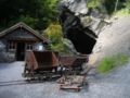
Agriculture and alpine farming as well as slate mining in the Landesplattenberg were the most important sources of income for the inhabitants of Engi until the 20th century.
traffic
Since the shutdown of the Sernftalbahn , the main road for individual traffic and bus operations of the Autobetriebe Sernftal AG has been Engi's only traffic development.
tourism
Hiking trails lead to Schwanden , the Suworowweg to Elm , to the Murgseen and to Murg and the Weissenberge. From early summer you can play on a newly built pitch & putt golf course.
The Engi ski lift is in operation in winter and the slope is illuminated at night. A cross-country ski run is groomed from Engi to Matt.
history
The name Engi comes from the Alemannic settlers. It is first mentioned in a document from the Säckingen monastery in 1350.
In 1408 the community bought the Gandalp, an alp in the state of Glarus on the left bank of the Sernf. Barley was mainly grown for personal use.
Since the 13th century, the inhabitants of Engi in the neighboring village of Matt were church-dwelling. A church was built and consecrated there in 1273. In 1528 the Reformation was introduced.
Slate mining in Engi was first mentioned in a document in 1565. Back then, strangers were forbidden from digging for slate. Due to the unfavorable transport conditions, mining was no longer competitive since the 17th century, because the panels had to be brought from the valley to Schwanden on pack animals .
The population growth, the Napoleonic wars with the passage of General Suvorov's army in October 1799, natural disasters and lack of earning potential led to a serious economic crisis. In the 19th century it forced many villagers to emigrate to North and South America.
The first road into the Sernftal has existed since 1826. Slate mining experienced an immediate boom and the state of Glarus took it over in 1833. This led to the new name of the Landesplattenberg slate mine . In 1855 the Sernftalstrasse was expanded. Leonhard Blumer founded the Sernftal weaving mill at the exit of the Mühlebachtal in 1864. He initiated a tram that was in operation from 1905 to 1969, today it has been replaced by a bus company.
Attractions
Landesplattenberg
Slate has been mined in the Landesplattenberg in Engi since the 16th century .
The fossil finds made the Plattenberg known among naturalists as early as the beginning of the 18th century. Interesting fish fossils, but also fossilized turtles and birds were found again and again. Johann Jakob Scheuchzer , the important natural scientist from Zurich, examined the Plattenberg in 1705. At Scheuchzer's instigation, all fossils were sent to him for payment to Zurich. From there they found their way to natural history museums in many European countries.
The Landesplattenberg was shut down in 1961 for industrial hygiene and economic reasons.
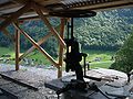
Since 1995 there have been guided tours in the Landesplattenberg in the summer half-year. An exhibition on the techniques of slate mining and its history can be viewed.
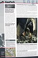
GeoPark Engi orientation board
View of Engi from the Landesplattenberg
Main tunnel entrance at Landesplattenberg

In the slate mine


Glarus Museum of Nature
Since 2004, the natural science collections of the Canton of Glarus have been brought together in one place and are accessible to the public. In the former office building of Weseta Textil AG, you can see animals, various herbaria, hundreds of slate fossils, rock and mineral collections as well as thousands of butterflies. Due to austerity measures by the canton of Glarus, the museum was closed on July 1, 2016 and is currently no longer open to the public.
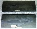
Fish fossils

Personalities
- Mathias Zopfi , politician of the Greens and Council of States
literature
- Karin Marti-Weissenbach: Engi. In: Historical Lexicon of Switzerland .
Web links
- Directory of field names on the website of the Engi local history association
- Landesplattenberg
Glarus | Glarus North | Glarus South
Former municipalities: Betschwanden | Bilten | Braunwald | Diesbach | Elm | Engi | Ennenda | Filzbach | Haslen | Hätzingen | Kerenzen-Mühlehorn | Leuggelbach | Linthal | Luchsingen | Matt | Mitlödi | Mollis | Mühlehorn | Näfels | Netstal | Nidfurn | Niederurnen | Head urns | Obstalden | Riedern | Rüti | Schwanden | Schwändi | Sool