Big house horn
| Big house horn | ||
|---|---|---|
|
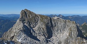
Great Häuselhorn from the southeast ( Wagendrischelhorn ) |
||
| height | 2284 m above sea level A. | |
| location | Salzburg , Austria | |
| Mountains | Reiter Alm ( Berchtesgaden Alps ) | |
| Dominance | 1.3 km → Stadelhorn | |
| Notch height | 229 m ↓ Mayrbergscharte | |
| Coordinates | 47 ° 36 '0 " N , 12 ° 47' 0" E | |
|
|
||
| Normal way | Marked climb from the north | |
The Great Häuselhorn (often wrong: Great Häuslhorn ) is at 2284 m above sea level. A. the second highest peak of the Reiter Alm in the Berchtesgaden Alps and lies entirely on Austrian territory. The Großer Häuselhorn is a climbing peak.
Routes
The mountain can be reached via a marked path from the Neue Traunsteiner Hütte to the north . Here, however, are climbing sections in difficulty I (UIAA) to overcome. This ascent is also done as a ski tour in winter . The Häuselhornrinne (difficulty II) leads through the steep south face, which is particularly important as a descent for the various climbing routes on the south face . A pathless transition leads to the southeast over the ridge to the Wagendrischelhorn .
Well-known climbing routes through the south face are Hasenalarm (VI), Direct Südwand (V +) and Hexentanz der Fersen (VII-).
Rock fall 2012
On June 4, 2012, a rock fall occurred, with around 10,000 cubic meters of rock breaking off in the ascent chimney in the south face. Safety hooks on climbing routes were destroyed.
Web links
Individual evidence
- ↑ Bernhard Kühnhauser: Alpine Club Guide Berchtesgaden Alps with Hochkönig . 20th edition. Bergverlag Rother , Munich 2011, ISBN 978-3-7633-1127-9 , pp. 174 .
- ↑ Federal Office for Metrology and Surveying : Austrian Map 1: 50,000, AMAP Online , accessed on August 26, 2012.
- ^ Bernhard Kühnhauser: Berchtesgaden Alps with Hochkönig. Alpine Club Guide : A guide for valleys, huts and mountains . 20th edition. Bergverlag Rother , Munich 2011, p. 458 .
- ↑ Hasenalarm , bergstieg.com , accessed on December 11, 2018.
- ↑ Climbing routes in the Berchtesgaden Alps , accessed on August 26, 2012.
- ↑ Large rock fall: Warning to climbers , orf.at, accessed on August 26, 2012.


