
Reiter Alm
| Reiter Alm | ||
|---|---|---|
 Reiter Alm from the east from Ramsau |
||
| Highest peak | Stadelhorn ( 2286 m above sea level ) | |
| location | Bavaria / Salzburg | |
| part of | Berchtesgaden Alps | |
|
||
| Coordinates | 47 ° 37 '0 " N , 12 ° 48' 0" E | |

The Reiter Alm , also Reiter Alpe , in Austria also Reither Steinberge , named after the Reit district of the municipality of Unken , is up to 2286 m above sea level. NHN high table mountains of the Berchtesgaden Alps in the federal states of Bavaria ( Germany ) and Salzburg ( Austria ). The Reiter Alm is the western boundary of the Berchtesgaden valley basin and rises to the east of the Saalachtal near Lofer and Unken .
Geographical location
The Reiter Alm covers an area of around 100 km², which extends on both sides of the German-Austrian border. The Bavarian part lies in the municipalities of Ramsau and Schneizlreuth ( district of Berchtesgadener Land ), the part in the Salzburg region belongs to the municipality of Unken ( Pinzgau ), which also includes the eponymous district of Reit , as well as the market municipality of Lofer and the municipality of Sankt Martin bei Lofer (southwest foothills of the Bergstock). To the west, the area slopes down to the Saalach, which is a southwest tributary of the Salzach . Immediately to the east below the Reiter Alm are the Hintersee and Taubensee .
Neighboring mountain groups are Hochkalterstock in the east, Lattengebirge in the northeast, Chiemgau Alps in the northwest, the Loferer Steinberge in the southwest, the Leoganger Steinberge in the south and the western foothills of the Steinerne Meer in the southeast.
landscape

The Reiter Alm falls steeply at its edges everywhere. Its plateau is covered, especially in the northern part, with alpine pastures and pastures as well as old pine forests. In the middle of the high plateau is the Reitertrett with the only spring, in the vicinity of which the old and the new Traunsteiner hut can be found. The eastern area of the Reiter Alm, the area of which is largely in the Berchtesgaden Biosphere Reserve , is part of the Berchtesgaden National Park , the area of which is congruent with the southern part of the Biosphere Reserve.
The northern half of the German area is a training area for mountain hunters , the "small mountain training area Reiteralpe" or also known as the "high mountain training area". This is also where the mountain testing and blasting site of the Defense Technical Center for Protection and Special Technology (WTD 52) is located. There operates Bundeswehr of Oberjettenberg from the cable car Reiteralpe . The hiking trail over the Schrecksattel leads right through the practice area. Outside of the practice times, which are indicated by flags at prominent access points, the entire military area can be entered at your own risk. Closures do not affect the path from the Schrecksattel to the Neue Traunsteiner Hütte . On the premises of the Bundeswehr there are, among other things, three different sized accommodations which are called Lenzenkaser I-III.
geology
Together with the Lattengebirge, Müllnerhorn , Untersberg and parts of the Watzmann ( Grünstein and Schapbachriedel), the Reiter Alm forms the Reiteralm ceiling or Berchtesgaden unit . This essentially consists of Dachstein limestone , which forms the conspicuous rock walls of the precipices and the plateau, and a base made of Ramsaudolomite . They lie on the basis of the Werfen layers , which is also the sliding horizon with which the Reiteralm ceiling was pushed onto the Jura-Neokom sub-base of the Tyrolean underground. In the area of Reitertrett remains of are Gosau chalk get that form the surface of the green pastures. Ramsaudolomite is mined in the Oberjettenberg Dolomite Works.
Flora and fauna
Huge pine fields dominate the plateau. The forest that used to exist there fell victim to the Reichenhaller saltworks need for wood. In 1829 the Reiter Alm was excluded from the saltworks contract because there was no longer enough forest. In the northern part there are still some old pine trees. On the alpine meadows of the Reitertrett, among other things, arnica, columbine, alpine roses, bergastern, edelweiss, gentian, speik and stone rue grow. Germany's highest raised bog is located in the northern part . Some black grouse live there . Another rare species is the mountain hare, while red deer and chamois are common.
Alpinism
Important peaks in the area of the Reiter Alm are the Große Häuselhorn ( 2284 m ), the Wagendrischelhorn ( 2251 m ), the Stadelhorn ( 2286 m ), the Schottmalhorn ( 2045 m ), the Edelweißlahnerkopf ( 1953 m ) or the Ameisnockenkopf ( 1925 m ) as well as the local mountains of the Traunsteiner Hütte, the Große Weitschartenkopf ( 1979 m ) and the Big Brother ( 1864 m ). Marked trails lead to all of these peaks.
The walls of the southern peaks between the Häuselhorn and the Grundübelhorn offer climbing trips of all levels of difficulty. Classics are the southern edge of the Großer Grundübelhorn (Feichtner, Langthaler 1913, V-), the direct southern edge of the Große Mühlsturzhorn ( Toni Kurz , Andreas Hinterstoisser , 1936, VIII- or VI-, A1-A2) and the straight south face of the Großer Häuselhorn (Kadner, 1920, V).
Some of the most difficult alpine sport climbing in Germany can be found in the area of the north falls . The most famous climbing mountains here are the Wartsteinwand , the Hintere Feuerhörndl and the Hirscheck - as well as the Alpawand , the Übeleck and the Alphorn, recently thanks to popular modern routes .
To the south, below the Stadelhorn, the Hirschbichlkamm , a ridge made of Ramsaudolomit, separates.
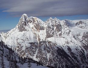
The southeastern peaks of the Reiter Alm: Mühlsturz- and Grundübelhörner

Stadelhorn, Wagendrischelhorn, Gr. Häuselhorn from the north ( Schottmalhorn )

Weitschartenkopf from the east

Stadelhorn from Wagendrischelhorn

View from the northeast from the Nonner Unterland

Panorama from the Wagendrischelhorn


Hiking trails
The easiest climbs lead over the Schrecksattel from Oberjettenberg on the west side, through the Alpatal from Reit in the southwest and over the Wachterlsteig from the Schwarzbachwacht on the east side of the Reiter Alm. The Böselsteig from Hintersee (Ramsau) and the Steig are also marked, but require sure-footedness over the Mayrbergscharte from Hintersee or Reit.
In winter, the Reiter Alm is usually reached via the Schrecksattel climb. On January 2, 2006, a little off this ascent in a steep gully, an avalanche accident with three fatalities occurred. Ski peaks are the large Weitschartenkopf, the Wagendrischelhorn and the eastern edge of the plateau. In very good conditions, the house horns can also be reached.
literature
- Fritz Hofmann : The Reiteralpe , Bad Reichenhall 2005, self-published
- Hermann von Barth: From the Northern Limestone Alps . Amthor, Gera 1874 ( digital version, PDF, 86 MB ); Reprint Bavarica-Reprint in Süddeutschen Verlag, Munich 1984, pp. 72-88, ISBN 3-7991-6217-8 .
On the geology of the Reiteralm cover:
- Dietrich Herm: Das Lattengebirge , in: Yearbook 1981/46. Year of the Association for the Protection of the Mountain World eV , Munich.
Web links
- Tour description , alpinisten.info - Schrecksattel climb incl. Map and photos
- Reitertrettalm (Reiteralm) . In: Agricultural and cultural heritage database . Society for Agricultural History
- Panorama from the Schottmalhorn