
Hintersee (Ramsauer Ache)
| Hintersee | ||
|---|---|---|

|
||
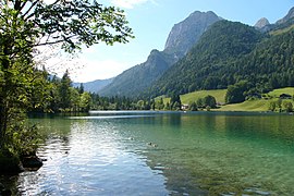
| Panorama from the northeast (Malerwinkel), in the background the Hochkalter massif | ||
| Geographical location | Bavaria , Germany | |
| Tributaries | Hinterseegraben, Toneckergraben, Antonigraben until approx. 1900: Klausbach |
|
| Drain | Sillersbach → Ramsauer Ache | |
| Places on the shore | Hintersee | |
| Data | ||
| Coordinates | 47 ° 36 '24 " N , 12 ° 51' 14" E | |
|
||
| Altitude above sea level | 789.06 m | |
| surface | 16.4 ha | |
| length | 830 m | |
| width | 480 m | |
| volume | 1,148,000 m³ | |
| scope | 2.5 km | |
| Maximum depth | 18.0 m | |
| Middle deep | 7.0 m | |
| Catchment area | 41.7 km² | |
.jpg)
|
||
| Aerial photo ( orthophoto ) of the lake and town | ||

The Hintersee (formerly Ferchensee or Forchensee , from Förche = trout ) is a 16.4 hectare lake in the municipality of Ramsau in Berchtesgadener Land , around two kilometers west of the center of Ramsau. The village of Hintersee is named after him, directly on its west bank with around 100 inhabitants, southwest of the Antenbichl Gnotschaft , to which it originally belonged.
geography
Emergence
The Hintersee at the foot of the Reiteralpe and the Hochkalter was formed around 3,500 to 4,000 years ago when a rock fall from the Blaueistal from the Hochkaltermassiv, which covers an area of 75 hectares , dammed the Klausbach , which rises at the Hirschbichl , and at the same time created the magic forest . In order to prevent further silting up by the sediment carried along, around 1900 the Klausbach was led around the Hintersee up to its overflow, the Sillersbach, before finally flowing into the Ramsauer Ache . Nevertheless, the lake today only has a third of its original area.
Location and landscape
The lake is entirely within the district forest district Hintersee , which until its incorporation to Ramsau near Berchtesgaden one on 1 January 1984. unincorporated community was. With its west bank, however, it borders on the district of Ramsau, specifically on the Hintersee district, which originally belonged to the Antenbichl community .
Today the lake is only fed by small inlets from the west and northwest. One of these is the Antonigraben , which rises below the Edelweißlahnerkopf and flows into the lake a few meters from the listed Antonikapelle (with hipped roof , 17th century).
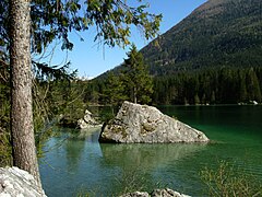
The lake has a maximum water depth of 18 meters and in the summer months a water temperature of a maximum of 15 to 16 degrees Celsius .
The Hintersee is known for its reflection of the Hohen Göll ("Göllspiegelung").
Development and use
General
The lake is owned by the Free State of Bavaria, for whose administration the Bavarian Administration of State Palaces, Gardens and Lakes is responsible.
The lake can be reached from Ramsau on foot through the magic forest . There is an electric boat line on the lake, and rowing boats and pedal boats can be hired. The YMCA guest house, as well as several hotels and restaurants, are located on the banks of the Hintersee .
( See also gastronomy in the article about the place )
Use in winter
The lake regularly freezes over in winter and is used by ice skaters, curlingers and hikers.
From the Hintersee you can get to the game feeding station in the Klausbachtal in about 30 minutes.
history

The important trade route led past Hintersee over the Hirschbichl into the Pinzgau , which contributed to the first settlement of Ramsau after the founding of the Berchtesgaden monastery .
After the establishment of the Free State of Bavaria, the forester's house on Hintersee was for King Ludwig III. the last stop in Bavaria before the Salzburg Anif his officers and soldiers in the " Anif declaration absolved" from the Pledge of Allegiance.
After the Obersalzberg was bombed , some of the NS functionaries were relocated to the Hintersee. Shortly before the end of the Second World War , the war diary of the High Command of the Wehrmacht (OKW) with all text and annex volumes was destroyed there on May 1, 1945 on the orders of General August Winter .
Culture
In the 19th century, a well-known painters' colony developed on the Hintersee , mainly made up of representatives from the Munich and Vienna Schools, including: Wilhelm Busch , Carl Rottmann , Ludwig Richter , Carl Schuch , Karl Hagemeister , Thomas Fearnley , Friedrich Gauermann , Ferdinand Waldmüller and Frederik Christian Kiærskou (1805-1891). Among them then u. a. Carl Rottmann also made the lake itself a motif. Many of them were served by the Auzinger inn and its predecessor, Hint. See Wirth as a meeting point and hostel. The so-called Ramsauer Malerweg leads from the Ramsau village center through the magic forest to the Hintersee along the preferred locations of the painters.
The Hintersee also served as the backdrop for several films.
After a break of more than 50 years, another lake festival was held on the Hintersee in August 2009 with a great response from the public. It is now carried out again every 4 years.
On Hintersee in 2010 under the National Park Festival , the Martinsklause Ganghofer staged as open-air performance.
Picture gallery

Johann Wilhelm Schirmer : The Hintersee near Berchtesgaden (1838)

Hintersee around 1900 ( photochromic print )

View of the ascent Schärtenspitze : Hintersee with the village of Hintersee
Hintersee near Ramsau with Mühlsturzhorn
Impressions at the Hintersee


Musicians at the Seefest 2013

Musicians at the Seefest 2013
.png)
.png)
See also
Web links
- Data sheet. Traunstein Water Management Office
- The Hintersee. Site of the Bay. Lock management
- Pictures of the Hintersee with its char Fischereiverein Berchtesgaden / Königssee e. V.
Individual evidence
- ↑ Bavarian State Office for Statistics and Data Processing (Ed.): Official local directory for Bavaria, territorial status: May 25, 1987 . Issue 450 of the articles on Bavaria's statistics. Munich November 1991, DNB 94240937X , p. 71 ( digital copy - 95 inhabitants in 22 buildings with living space and 37 residential units).
- ^ Community of Ramsau - history. ramsau.de
- ↑ Percy E. Schramm (Ed.): War diary of the High Command of the Wehrmacht . Licensed edition for Verlagsgruppe Weltbild, Augsburg 2005, ISBN 3-8289-0525-0 , Volume 2, first half volume, p. 569.
- ↑ a b c d Georg Weindl: A life between easel and tavern . In: Frankfurter Allgemeine Zeitung , May 7, 2003
- ↑ a b c d e f g auzinger.de On the history of the Gasthof Auzinger
- ^ Ramsauer Malerweg. Berchtesgadener Land Tourismus GmbH, accessed on December 18, 2013 .
- ↑ Seefest on and around the Hintersee . BGLand24.de, August 31, 2009.
- ↑ official festival homepage ( Memento from June 15, 2013 in the Internet Archive )