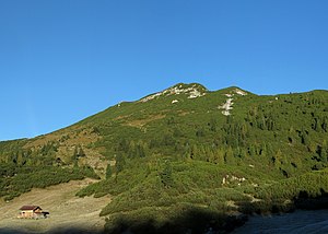
Big wide chart head
| Big wide chart head | ||
|---|---|---|
|
Weitschartenkopf from the east |
||
| height | 1979 m above sea level A. | |
| location | Salzburg , Austria | |
| Mountains | Reiter Alm , Berchtesgaden Alps | |
| Dominance | 2.5 km → Großes Häuselhorn | |
| Notch height | 349 m ↓ Guggenbühel saddle | |
| Coordinates | 47 ° 37 '55 " N , 12 ° 47' 10" E | |
|
|
||
| rock | Banked Dachstein limestone | |
| Age of the rock | Norium - Rhaetium | |
| Normal way | South flank | |
The Great Weitschartenkopf is at an altitude of 1979 m above sea level. A. the highest mountain in the northwestern part of the Reiter Alm . It is located in the state of Salzburg in Austria in the immediate vicinity of the Bavarian border. A good 500 meters northeast of its summit is on the German side of 1930 m above sea level. NHN high small wide chart head .
The Große Weitschartenkopf is approached from the Neue Traunsteiner Hütte . The marked path leads, without difficulty, over the plateau to the west in 1.5 hours, before, after reaching the north-west slope of the Reiter Alm, it heads north-east to the summit. There are no marked paths leading to the Kleiner Weitschartenkopf.
The view from the Großer Weitschartenkopf allows a very good overview of the high plateau of the Reiter Alm. In the east and south-east you can see Hoher Göll , Watzmann and Hochkalter , in the south-west the Loferer Steinberge , to the left of it the Großvenediger . To the west, the view extends to the Wilder Kaiser and across the Chiemgau Alps to the Bavarian Prealps . With very good visibility, there is the farthest view to the north as far as the heights of the Bavarian Forest around 200 kilometers away. In addition, the Großer Weitschartenkopf offers deep views of the Saalach valley with the core town of Schneizlreuth .

Web links
- Large Weitschartenkopf on roberge.de
- Panorama shot from the Großer Weitschartenkopf on alpen-panoramen.de with switchable summit names

