
Schneizlreuth
| coat of arms | Germany map | |
|---|---|---|

|
Coordinates: 47 ° 41 ' N , 12 ° 48' E |
|
| Basic data | ||
| State : | Bavaria | |
| Administrative region : | Upper Bavaria | |
| County : | Berchtesgadener Land | |
| Height : | 511 m above sea level NHN | |
| Area : | 107.28 km 2 | |
| Residents: | 1284 (Dec. 31, 2019) | |
| Population density : | 12 inhabitants per km 2 | |
| Postal code : | 83458 | |
| Primaries : | 08651, 08665 | |
| License plate : | BGL, BGD, LF , REI | |
| Community key : | 09 1 72 131 | |
| LOCODE : | DE TO | |
| Address of the municipal administration: |
Schneizlreuth No. 5 83458 Schneizlreuth |
|
| Website : | ||
| Mayor : | Wolfgang Simon ( FWG ) | |
| Location of the community of Schneizlreuth in the Berchtesgadener Land district | ||
  |
||


Schneizlreuth (today's spelling shows since 1875, earlier Schnaizlreut and Schneitzlreith ) is a municipality in the Upper Bavarian district of Berchtesgadener Land .
geography
location
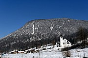
Schneizlreuth belongs to the administrative region of Upper Bavaria in the Free State of Bavaria . The municipality is located in the Berchtesgadener Land district and is surrounded by mountains of the Berchtesgaden and Chiemgau Alps .
The largest rivers in the municipality are the Saalach and its side stream, the Weißbach . The Weißbach narrows between the districts of Weißbach and Schneizlreuth, running parallel to the B305 federal road to the Weißbach Gorge. This gorge is a popular hiking destination.
Neighboring communities
The neighboring communities within the Berchtesgadener Land district are Bayerisch Gmain and Bad Reichenhall in the east, Bischofswiesen in the southeast and Ramsau near Berchtesgaden in the south . To the west , Unken , located in the Austrian state of Salzburg , borders on Schneizlreuth, to the north the two municipalities of the district of Traunstein , Ruhpolding and Inzell .
Community structure
The community is divided into a total of seven districts . These are the three former municipalities of Jettenberg , Ristfeucht and Weißbach an der Alpenstraße , as well as four formerly uninhabited, municipality-free areas or parts thereof that were incorporated at different times:
- Karlsteiner Forst (on January 1st, 1978 split between Weißbach an der Alpenstraße and Karlstein )
- Weißbacher Forst (incorporated into Weißbach an der Alpenstraße on January 1, 1978)
- Jettenberger Forst (split between Schneizlreuth and Ramsau on January 1st, 1984 )
- Forest St. Zeno (remaining area on January 1, 2011 divided between Schneizlreuth and Bad Reichenhall)
The eleven named municipal parts are distributed over the three inhabited districts:
| Schl | District | Area ha |
1987 residents |
Parish parts | Incorporation |
|---|---|---|---|---|---|
| 9945 | Instep damp | 1440.67 | 389 | Fronau , Melleck , Ristfeucht , Schneizlreuth, Ulrichsholz , Kibling 1 | July 1, 1909 |
| 9946 | Jettenberg | 1440.67 | 266 | Oberjettenberg , Unterjettenberg , Baumgarten 1 | July 1, 1909 |
| 9943 | Weißbach on the Alpine Road | 461.76 | 609 | Jochberg , Weißbach on the Alpine Road | May 1, 1978 |
| 9942 | Karlstein Forest | 1235.18 | - | (uninhabited) | Jan. 1, 1978 (to Weißbach) |
| 9944 | Weißbach Forest | 2863.94 | - | (uninhabited) | Jan. 1, 1978 (to Weißbach) |
| 9967 | Jettenberger Forest | 2279.77 | - | (uninhabited) | Jan. 1, 1984 |
| 9953 | Forest of St. Zeno | 966.50 | - | (uninhabited) | Jan. 1, 2011 |
| Schneizlreuth community | 10727.57 | 1264 | 11 districts |
Population development
Between 1988 and 2018 the community grew from 1,256 to 1,309 by 53 inhabitants or 4.2%.
history
prehistory
In 1285 an estate was first named Schnaezenreut, on which the first post office ( today: Gasthaus Schneizlreuth) was set up in 1590 . The first documentary mention of Weißbach was on August 1, 1349. After the Salzburg Land was elevated to the status of the Prince Archbishopric of Salzburg, both localities remained with the Duchy of Baiern .
In 1346, Emperor Ludwig had the "Güldene Salzstraße" or the Goldener Steig expanded over the Jochberg . As a result, both localities were part of an important connection between Reichenhall with its saltworks and the rest of the ducal Bavarian dominion.
During the Napoleonic Wars and the associated Tyrolean popular uprising (1809), there were several battles over the Steinpass , which is close to Schneizlreuth and therefore important , and which the Tyroleans were able to hold for some time until Bavaria immediately recaptured it.
20th century
The community was created on July 1, 1909 from the union of the communities Jettenberg (with the districts Oberjettenberg and Unterjettenberg ) and Ristfeucht (including Schneizlreuth, at that time still a hamlet ).
On May 5, 1945, the presumably last battles of the Second World War in Bavaria took place in Schneizlreuth .
On July 1, 1972, Schneizlreuth formed the new Bad Reichenhall district with the other communities of the old Berchtesgaden district , the previous independent city of Bad Reichenhall and the southern communities of the previous Laufen district , which was renamed the Berchtesgadener Land district on May 1, 1973 .
The municipality of Weißbach an der Alpenstrasse, founded in 1883, was incorporated into Schneizlreuth on May 1, 1978 as part of the municipal reform. On January 1, 1984, the larger, northern part of the community-free area Jettenberger Forst was incorporated.
21st century
On January 1, 2011, part of the previously unincorporated area of Forst St. Zeno was incorporated.
In May 2015, six men were killed in a major fire in the parish farm . The historic building on the B 21 not far from the Schneizlreuth town hall was used as a guest house by an event company. The former mayor of the municipality and the owner of the event agency had to answer in court after the fire. The former mayor was sentenced to a suspended sentence of ten months for using the building in violation of building regulations and not carrying out a fire inspection. The owner of the event agency was sentenced to three years in prison for negligent homicide.
politics
Municipal council
The Schneizlreuth local council consists of twelve councilors and the mayor. In the local elections on March 15, 2020 , the Free Voting Association Weißbach adA received seven seats and the Independent Wahlgemeinschaft Schneizlreuth five seats. In the 2014 to 2020 term of office, both groups of voters each had six representatives on the municipal council.
mayor
Wolfgang Simon was elected to succeed Klaus Baueregger in March 2014 by a narrow margin. Simon was elected unopposed on March 15, 2020 with 95.81% of the vote for a further six years.
Constituencies
Schneizlreuth belongs to the Traunstein Bundestag constituency and the Berchtesgadener Land constituency for state and district elections.
Banner and coat of arms


|

|
|
|
Coat of arms: left Schneizlreuth,
re. Weißbach an der Alpenstraße before the merger in 1978 |
||
|
|
Blazon : "In blue over the silver three-mountain, a golden wheel from which three silver brine pipes grow in the shape of a goblet, each topped by a golden clover." |
|
Reasons for the coat of arms: The choice of heraldic symbols, some of which already appear in the coat of arms of the former communities of Schneizlreuth and Weißbach a d. Alpine Road were included, should highlight their merging in 1978. The golden wheel stands for the "Güldene Salzstraße" from Reichenhall to Traunstein, on whose route the municipality lay and owed its development. The three brine pipelines growing out of the wheel refer to the brine pipeline from Reichenhall to Traunstein built by Duke Maximilian I between 1611 and 1619 , for which wooden pipes were manufactured in Schneizlreuth well into the 19th century. The Dreiberg, which is already part of the Weissbach coat of arms next to a brine tower, symbolizes the alpine landscape around Schneizlreuth in general. The shamrocks were taken from the earlier Schneizlreuth coat of arms and come from the family coat of arms of the Barons von Lasser, who held the Hofmark Marzoll for almost two centuries until 1798 and were the most important landlords in Ristfeucht and Jettenberg. The shamrocks should also stand for the alpine farming that is prevalent in the municipality .
The coat of arms was introduced in 1981 on the legal basis of a resolution of the municipal council and with the consent of the government of Upper Bavaria. (The letter from the government of Upper Bavaria is dated June 3, 1981.) The municipality colors of the flag are yellow - blue - white. |
Attractions
Many of the sights in the community of Schneizlreuth are of natural origin. These include u. a. the Aschauer Gorge , the Weißbach Gorge , the Glacier Garden and the mountains in the immediate vicinity with countless opportunities for hiking and refreshment stops.
Buildings
The listed objects are listed in the list of architectural monuments in Schneizlreuth .
Alpine pastures
Many of the alpine pastures in the high areas around Schneizlreuth are still in use today. Partly agricultural, partly as a hosted alpine hut as a destination for hikers. These include u. a. the Anthauptenalm , the Bichleralm , the Dalsenalm , the Harbachalm , the Moosenalm and the Schwarzbachalmen .
Klausen
The forests in the municipality were used as a wood supplier for the saltworks in Reichenhall as early as the Middle Ages . The wood from the high elevations of the mountains was brought down to the valley by means of a wooden drift and further over the waters of the Saalach and the Reichenhaller drift systems to the saltworks. For this purpose, countless Klausen were built in the mountains, many of which are still preserved today. These include the Aschauer Klause , the Bäckinger Klause , the Hientalklause , the Kastnerklause and the Röthelbachklause . The Steinbachklause, built mainly of wood, was already badly damaged in the 1970s. Most of the remainder of the more than a dozen Klausen in today's Schneizlreuth are barely visible.
Well houses and brine pipeline
In Weißbach an der Alpenstraße , two of the wells of the brine pipeline from Reichenhall to Traunstein are still preserved today. The Brunnhaus Grub is located near the Gasthof Alpenglück on Brunnhausweg, the Brunnhaus Nagling is at the end of the village on Inzeller Straße ( B305 ).
Churches and chapels
- The Maria Hilf branch church in Schneizlreuth, part of the town church of Bad Reichenhall, is a clapboard-roofed choir tower church. It was built in the years 1946–1949. A renovation took place in 1973/74. The raised onion should be reminiscent of a candle flame. It is crowned by a tower ball with a cross on which a flying angel with a trumpet is attached as a weather vane . The church door in the eastern porch is decorated with carving: the Jesus monogram can be seen in the upper panel, the Marian monogram in the lower panel . A bronze cross by the sculptor Karl Richter hangs above the popular altar in the retracted, almost square choir .

Filial church Maria Hilf

Tower cross with weather vane

Door in the east porch

Maria Hilf, interior view


- The St. Vinzenz branch church and the Jochberg chapel are located in Weißbach an der Alpenstrasse .
Church of St. Vincent

Jochberg Chapel


Economy and Infrastructure
tourism
The tourism in Schneizlreuth was advertised by the district-wide marketing company Berchtesgadener Land Tourismus GmbH (BGLT) until 2016 and the community was also a member of the regional tourism association Erlebnisregion Berchtesgadener Land - Rupertiwinkel - eV. Besides Ainring, Schneizlreuth is one of the two only communities in the district, which cannot or can no longer be advertised by the marketing company. Since it left the tourism association, the municipality has been soliciting tourists independently. There was no drop in the number of guests and overnight stays, and in 2016 the number of overnight stays even increased.
Other industries
Ramsaudolomite is mined in the Jettenberg dolomite plant and mainly processed into dolomite flour and grains for industrial purposes.
traffic
Schneizlreuth is accessed by the German Alpine Road (including B 305 ) from Inzell in the northwest and Ramsau in the southeast. The B 21 connects the community with Bad Reichenhall in the north and Unken and Lofer in Austria in the south. This street is also referred to by the Austrian side as the “ Kleines Deutsches Eck ”. The small district of Melleck is located below the Steinpass , over which a side road leads to Unken.
The nearest train stations are in Bad Reichenhall and Traunstein .
State institutions
In the district of Oberjettenberg there is the Defense Technical Service for protective and special technology of the Bundeswehr, including the Reiteralpe cable car .
Personalities
- Hans-Georg Beck (1910–1999), Byzantinist
- Bally Prell (1922–1982), folk singer, made herself and the place known throughout Germany in 1953 with her song about the "Beauty Queen of Schneizlreuth".
Web links
- Schneizlreuth community
- Entry on the coat of arms of Schneizlreuth in the database of the House of Bavarian History
- Schneizlreuth: Official statistics of the LfStat
- Location of Schneizlreuth in the BayernAtlas (accessed on October 16, 2016)
Individual evidence
- ↑ "Data 2" sheet, Statistical Report A1200C 202041 Population of the municipalities, districts and administrative districts 1st quarter 2020 (population based on the 2011 census) ( help ).
- ^ Complete list of localities of the Kingdom of Bavaria . Adolf Ackermann, Munich 1877, p. 54.
- ↑ a b Repertory of the topographical atlas sheet Reichenhall 1840, p. 34.
- ^ Tax cadastre commission in the Kingdom of Bavaria (1808–1964). First recording [card], 1: 2500.
- ^ Official register of places for Bavaria, edited on the basis of the census of September 13, 1950, Munich, 1952 , column 71 and [1]
- ↑ Bayerische Landesbibliothek Online: The original position sheets of the land survey in Bavaria Reichenhall and the surrounding area in 1832 (1: 25000); see also BayernAtlas : first recording (1: 5000)
- ↑ Gasthaus Schneizlreuth , brief historical review, online at gasthaus-schneizlreuth.de
- ↑ For the whole section: A brief overview of the historical development of our community , online at schneizlreuth.de , accessed on May 16, 2016
- ↑ bgland24.de Wars, upswings and avalanches - 100 years of Schneizlreuth
- ↑ History schneizlreuth.de,
- ↑ regierung.oberbayern.bayern.de See Upper Bavarian Official Gazette, No. 26/30 December 2010, PDF file p. 1 and 2 of 6 pages
- ↑ Fire in Schneizlreuth: This is how the fire ended with six dead on bgland24.de, accessed on June 3, 2020
- ↑ Fire disaster in Schneizlreuth: Ex-Mayor sentenced to suspended sentence on sueddeutsche.de, accessed on June 3, 2020
- ↑ 2014 local elections - Schneizlreuth , report from March 18, 2014, online at bgland24.de
- ↑ a b c d Entry on the Schneizlreuth coat of arms in the database of the House of Bavarian History , accessed on September 7, 2017 .
- ↑ Tourism on schneizlreuth.de, accessed on August 4, 2019
- ↑ http://www.kath-stadtkirche-badreichenhall.de/index.php?id=82
- ^ Website St. Vinzenz Weißbach
- ↑ a b Schneizlreuth - Discussions about “Erlebnisregion BGL” , report from March 10, 2017 in the Passauer Neue Presse , online at pnp.de.
- ↑ Holidays in Schneizlreuth and Weißbach adAlpenstraße , online at schneizlreuth.de
- ↑ Bavarian State Office for Statistics : Statistics communal 2019 , PDF file, on tourism since 2013 see. P. 16 of 30 pages, online at statistik.bayern.de
- ^ Website Dolomitwerk Jettenberg
Ristfeucht district:
Fronau |
Kibling |
Melleck |
Damp | Schneizlreuth |
Ulrichsholz
district Jettenberg :
Baumgarten |
Oberjettenberg |
Unterjettenberg
District Weißbach an der Alpenstraße:
Jochberg |
Weißbach on the Alpine Road

Ainring | Anger | Bad Reichenhall | Bayerisch Gmain | Berchtesgaden | Bischofswiesen | Freilassing | Running | Marktschellenberg | Piding | Ramsau near Berchtesgaden | Saaldorf-Surheim | Schneizlreuth | Schönau am Koenigssee | Teisendorf
Unparished areas:
Eck |
Schellenberger Forest