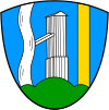
Weißbach on the Alpine Road
|
Weißbach on the Alpine Road
municipality Schneizlreuth
|
|
|---|---|
| Coordinates: 47 ° 43 ′ 7 " N , 12 ° 46 ′ 23" E | |
| Height : | 614 m |
| Incorporation : | May 1, 1978 |
| Postal code : | 83458 |
| Area code : | 08665 (local network Inzell) |
Weißbach an der Alpenstraße (officially: Weißbach ad Alpenstraße ; formerly only Weißbach ; today mostly abbreviated as Weißbach ad Alpenstraße ) is a district and a district of the municipality of Schneizlreuth in the Berchtesgadener Land district . Until 1978 Weißbach was an independent municipality. The name is composed of the name of the river Weißbach and the location on the German Alpine Road .
history

On August 1, 1349, Weißbach was first mentioned in a document, and a Schnaezenreut estate was first mentioned in 1285. Both villages remained with the Duchy of Baiern after Salzburg became land . They formed the important link between Reichenhall with its important saltworks and the rest of the ducal Bavarian dominion.
Weißbach became a municipality within the Kingdom of Bavaria on September 25, 1883.
On January 1, 1978, the municipality-free area Weißbacher Forst (2863.94 hectares ) was incorporated and the Karlsteiner Forst was divided between Weißbach an der Alpenstraße (1235.18 hectares) and Karlstein . The incorporation of the forest areas increased the area of the municipality almost tenfold from 461.76 to 4560.88 hectares.
Until the completion of the municipal reform , Weißbach an der Alpenstraße was an independent municipality and has belonged to Schneizlreuth since May 1, 1978.
coat of arms
| Blazon : "In blue on a green three-mountain between a silver (white) wave post and a gold (yellow) post, a silver (white) brine tower, which is connected to the wave post via a double inclined brine pipe." | |
| Reasons for the coat of arms: The coat of arms is reminiscent of the " Güldene Salzstraße " from Bad Reichenhall to Traunstein , on the route of which the community lay and owed its development, on the one hand by the brine tower and on the other hand by the golden pole, which reminds of the brine pipeline . The shaft pole stands talking to the place name. |
geography
The district lies between the Schneizlreuth district and the municipality of Inzell .
The federal highway 305 , which is part of the German Alpine Road and leads from Berchtesgaden over two passes to the Chiemsee, runs through the district. The Weißbach brook runs parallel to this and narrows to the Weißbachschlucht gorge between the districts of Weißbach and Schneizlreuth. The gorge is a popular hiking destination.
Web links
Individual evidence
- ↑ http://www.saalacherlebniswelt.com/Schneiz1/Schneiz2/Schneiz3/schneiz3.html
- ↑ http://www.schneizlreuth.de/geschichte
- ↑ Unser Bayern , local supplement of the Bayerische Staatszeitung , 1964, p. 40; see Schneizlreuth: Weißbach adAlpenstraße , online at kommunalflaggen.eu .


