
Loferer Steinberge
| Loferer Steinberge | |
|---|---|
 Panorama of the Loferer Steinberge from Sankt Ulrich am Pillersee |
|
| Highest peak | Großer Ochsenhorn ( 2511 m above sea level ) |
| location | Pinzgau , Salzburg / Kitzbühel District , Tyrol |
| part of | Loferer and Leoganger Steinberge / Waidringer Alps ; North Tyrol-Salzburg Limestone Alps |
| Classification according to | Triumph 1323 |
| Coordinates | 47 ° 33 ' N , 12 ° 38' E |
The Loferer Steinberge are a mountain group of the Northern Limestone Alps in the Eastern Alps . You are in Austria in the federal states of Tyrol and Salzburg .
Location and landscape
The Loferer Steinberge are separated by the 1202 m high Römersattel from the Leoganger Steinberge, which adjoins it to the southeast . In the AVE, the Alpine Club division of the Eastern Alps , both mountain ranges are defined as a single subgroup ( Loferer and Leoganger Steinberge ). Loferer and Leoganger Steinberge together are also called general Steinberge . In front of the Loferer Steinberge to the west is the Kirchbergstock .
Typical for the Steinberge are plateau poles with steep slopes and strongly undulating high cirques. The stone mountains tend to form karsts. In the high plateaus and karen you can often find deep sinkholes, some of which are connected to underground cave systems. A cave through the Loferer Steinberge that can only be entered with a cave guide is the Prax ice cave .
The Großer Ochsenhorn forms with 2511 m above sea level. A. The highest elevation above sea level. The ascent to the Loferer Skihörndl ( 2286 m ) is one of the most famous ski tours in the Eastern Alps. The famous ski area of the Loferer Alm, on the other hand, is no longer in the Loferer Steinberge, but on the Steinplatte .
The easternmost part of the Loferer Steinberge belongs to the Saalforsten , namely forest district 18 Rechtschütt in the St. Martin district.
geology
The base of the Steinberge from a height of 600 m is formed by layers of Werfen slate from the Upper Permian or the Lower Triassic . These red, more rarely green and purple colored layers are impermeable to water, so that many springs come to light in these layers. The following layer with a more complex structure consists of Rauhwacke and Gutensteiner Kalk in the lower regions . A layer of Ramsaudolomite or main dolomite follows from a height of 1100 m . This is followed by a very thin band of marl from the Middle Triassic. This is also known as the Raibler layer . Now up to an altitude of about 2000 m there is a layer of dolomite that is very prone to erosion. The strong tendency of this rock to erosion explains some very typical erosion phenomena under the actual summit structures of the stone mountains. In these lower rock areas, the rock is very brittle and splintery, which makes it rather unpopular for climbing. At this altitude one often finds deep trenches, gullies and gullies as well as larger debris cirques. Now comes the final layer, which consists of Dachstein limestone and is up to 500 m thick. The characteristic Hochkare of the Steinberge, such as the large weir pit or the Ulricher pit, are products of the glaciations of the last ice age. Due to erosion, these cirques are mostly heavily karstified and have many sinkholes and caves. These sinkholes can be several hundred meters deep (e.g. Loferer Schacht ). Since the limestone layers are permeable to water, no springs can be found in the karst areas. The drainage takes place underground. During the Ice Age, the Loferer Steinberge were completely enclosed by the glaciers emerging from the Central Alps . The maximum ice height is derived from various glacier cuts and was around 2000 m. After the glaciers receded at the end of the Ice Age, a plateau glaciation such as the Übergossene Alm on the Hochkönig could not be maintained due to the insufficient height. Nevertheless, some snow fields that lasted all year round were able to maintain or form. On the south side between Mitterhorn and Geiselhörner there is a permanent snow field in a protected cirque that could be seen as a “dwarf glacier”.
climate

Due to their superior location close to the northern edge of the Alps, the Loferer Steinberge show a mixture of continental and oceanic climate. It should be noted that the north and north-west sides have a higher average rainfall rate than the south and south-east sides. The temperature fluctuations that occur in the course of the year are quite continental, so very pronounced. In summer, temperatures of 30 ° C or more can often be found in sheltered areas on the south side. In winter, however, the temperature can also drop to −30 ° C , often in the rough nights between Christmas and early January. A closed snow cover is usually found in the valleys from the beginning of December to April. The annual average temperature is 7 ° C (as of 1990). In summer, the thunderstorm tendency is particularly pronounced in June and July. Such thunderstorms can sometimes be very violent and be accompanied by hailstorms. Summer snowfall is also occasionally possible up to alpine height. In autumn, stable foehn weather conditions often form with relatively mild temperatures and extremely clear visibility.
Development history
Most of the summits have always been sporadically climbed by hunters and locals. The systematic tourist development of the Steinberge began in the 1830s. In 1833 Karl Thurwieser climbed the Große Hinterhorn . In addition to local hunters, mountaineers such as Purtscheller , Cranz, Doppler and Fill stood out during this period . In 1888 the Passau section of the German Alpine Club took over the management of the Loferer and Leoganger Steinberge, which gave new impetus to the development. The Großer Ochsenhorn was climbed by Cranz in 1897. In 1899 the Schmidt-Zabierow-Hütte was opened on the edge of the large weir pit. In the inter-war years, when interest in the neighboring, famous emperor waned somewhat, the Steinberge caught the interest of some climbers, including Willy Merkl , who was killed during the German Nanga Parbat expedition in 1934 . They opened up some new climbing routes. From the 1960s and 70s, local climbers and mountain guides opened up many new routes. There are now two via ferratas in the Steinberge. Overall, however, the Loferer Steinberge are still an alpine side show, which is partly due to the fact that there are no lifts to make the ascent easier and the approaches are consistently long and arduous.
Summit of the Loferer Steinberge
- Großer Ochsenhorn ( 2511 m above sea level )
- Mitterhorn (Großes Hinterhorn) ( 2506 m )
- Great Reifhorn ( 2480 m )
- Breithorn ( 2413 m )
- Nebelhorn ( 2056 m )
- Great Rothorn ( 2409 m )
- Rothörnl ( 2394 m )
- Geislhörner ( 2291 m )
- Seehorn ( 2155 m )
- Zwölferhörnl ( 2104 m )
- Ulrichshorn ( 2032 m )
- Vorderhorn ( 2109 m )
- Eiblhorn ( 1993 m )
Valley locations
Neighboring mountain groups
The Loferer Steinberge border the following other mountain groups in the Alps:
- Chiemgau Alps (in the north)
- Berchtesgaden Alps (in the east)
- Leoganger Steinberge (in the southeast)
- Kitzbühel Alps (in the southwest)
- Kaiser Mountains (in the west)
tourism
Alpine Club huts
In the Loferer Steinberge there is only one Alpine Club hut, which is 1966 m above sea level. A. located Schmidt-Zabierow hut .
In addition, on a private initiative, a bivouac box was set up in the snow pit below the Ochsenhorn. Altitude: 1750 m above sea level A. , walking time from St. Martin: 3½ hours.
Mountain hikes and tour options
- The Nuaracher Höhenweg over the western peaks of the Loferer Steinberge is known nationwide.
- Nackter-Hund-Klettersteig on the Mitterhorn / Großes Hinterhorn
- The ascent to the Schmidt-Zabierow-Hütte and the Nuaracher Höhenweg are part of the European long-distance hiking trail E4 Alpin .
photos
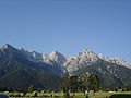
Loferer Steinberge from St. Ulrich am Pillersee

large ox horn from the large weir pit

Loferer mountains from Hartkaiser seen from

Loferer Steinberge from the Birnhorn

Loferer Steinberge from the Großer Häuselhorn on the Reiter Alm


literature
- Adi Stocker: Loferer and Leoganger Steinberge. Panico Alpinverlag, Köngen 2016, ISBN 978-3-95611-057-3 .
- H. Cranz: The Loferer Steinberg. In: Journal of the German and Austrian Alpine Association , Volume 31, 1900, pp. 211–226 ( digitized version ).